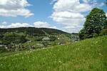
Königsheide (Fichtel Mountains)
The Königsheide is a high, forested ridge, made of gneiss-phyllite rock in the Fichtel Mountains in Bavaria, Germany. It is located to the southwest of the Ochsenkopf mountain. It is bordered to the east and south by the river of the Warme Steinach, and to the west by the Franconian Line. The villages of Warmensteinach and Weidenberg and the town of Goldkronach lie on the Königsheide. In a narrower sense the Königsheide refers to the partly boggy high plateau around its highest peak, the Hohberg (863 m above sea level (NN)). The origin of the name of this forested ridge has not been fully established. In 1317 the region was called Wulwingesheide and then, in 1542, the Königsheide ("King's Heath").
Excerpt from the Wikipedia article Königsheide (Fichtel Mountains) (License: CC BY-SA 3.0, Authors).Königsheide (Fichtel Mountains)
Himmelsleiter,
Geographical coordinates (GPS) Address Nearby Places Show on map
Geographical coordinates (GPS)
| Latitude | Longitude |
|---|---|
| N 49.9911 ° | E 11.747 ° |
Address
Forstrevierstein Mahlsack
Himmelsleiter
95497
Bavaria, Germany
Open on Google Maps


