Admiralenbuurt
Amsterdam-WestNeighbourhoods of AmsterdamNorth Holland geography stubs

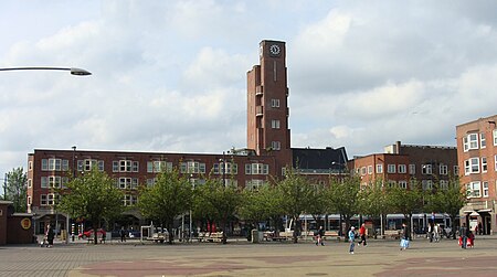
Admiralenbuurt (Dutch pronunciation: [ɑtmiˈraːlənˌbyrt]) or Mecatorbuurt (Dutch pronunciation: [mɛrˈkaːtɔrˌbyrt]) is a neighbourhood of the West borough of Amsterdam, Netherlands. It was constructed in the 1920s. The neighbourhood is bisected by the Admiralengracht. From 1990-2010, it was part of the borough of De Baarsjes; in 2010, it became part of the borough of Amsterdam-West along with the rest of De Baarsjes.
Excerpt from the Wikipedia article Admiralenbuurt (License: CC BY-SA 3.0, Authors, Images).Admiralenbuurt
Bartholomeus Diazstraat, Amsterdam West
Geographical coordinates (GPS) Address Nearby Places Show on map
Geographical coordinates (GPS)
| Latitude | Longitude |
|---|---|
| N 52.369783333333 ° | E 4.8530388888889 ° |
Address
Bartholomeus Diazstraat 27-H
1057 TA Amsterdam, West
North Holland, Netherlands
Open on Google Maps


