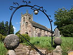
Mayfield, Staffordshire
Aviation accidents and incidents locations in EnglandStaffordshire MoorlandsTowns and villages of the Peak District

Mayfield is a village on the outskirts of Ashbourne in Derbyshire, about 9 miles from Uttoxeter, situated in East Staffordshire. The village is divided into Mayfield, Church Mayfield, Lower Mayfield, Upper Mayfield and Middle Mayfield. It has a population of approximately 2000. It lies on the banks of the River Dove. The Dove is the boundary between Derbyshire and Staffordshire. Mayfield is on the Staffordshire side of the border but it has an Ashbourne postal address because its nearest postal town, Ashbourne, is in Derbyshire. Derbyshire is not used by Royal Mail.
Excerpt from the Wikipedia article Mayfield, Staffordshire (License: CC BY-SA 3.0, Authors, Images).Mayfield, Staffordshire
Conygree Lane, East Staffordshire Church Mayfield
Geographical coordinates (GPS) Address Nearby Places Show on map
Geographical coordinates (GPS)
| Latitude | Longitude |
|---|---|
| N 53.0065 ° | E -1.7685 ° |
Address
Conygree Lane 11
DE6 2HY East Staffordshire, Church Mayfield
England, United Kingdom
Open on Google Maps


