place

Trier Air Base

Airports established in 1910Airports in Rhineland-PalatinateDefunct airports in GermanyTrierWorld War II airfields in Germany
RF 80s 10th TRW over Trier Air Base 1955

Trier Air Base, also known as Trier Euren Airfield, is a former military airfield located in the southwest of Trier, a city in Rhineland-Palatinate, Germany. It was established in 1910. During World War I it was used by the Deutsche Luftstreitkräfte as both a Zeppelin and military airfield. Later, it was used by the Air Service, United States Army, Deutsche Luftwaffe, the United States Army Air Forces, and NATO forces until being closed in 1977, when the airfield was converted into an industrial park.

Excerpt from the Wikipedia article Trier Air Base (License: CC BY-SA 3.0, Authors, Images).

Trier Air Base
Niederkircher Straße, Trier Euren (Euren)

Geographical coordinates (GPS) Address Nearby Places
placeShow on map

Wikipedia: Trier Air BaseContinue reading on Wikipedia

Geographical coordinates (GPS)

Latitude Longitude
N 49.723888888889 ° E 6.6027777777778 °
placeShow on map

Address

Schloss Wachenheim

Niederkircher Straße 27
54294 Trier, Euren (Euren)
Rhineland-Palatinate, Germany
mapOpen on Google Maps

RF 80s 10th TRW over Trier Air Base 1955
Share experience

Nearby Places

Saar (river)
Saar (river)

The Saar (German: [zaːɐ̯] ; French: Sarre [saʁ]) is a river in northeastern France and western Germany, and a right tributary of the Moselle. It rises in the Vosges mountains on the border of Alsace and Lorraine and flows northwards into the Moselle near Trier. It has two headstreams (the Sarre Rouge and Sarre Blanche, which join in Lorquin), that both start near Mont Donon, the highest peak of the northern Vosges. After 246 kilometres (153 mi) (129 kilometres; 80 miles in France and on the French-German border, and 117 kilometres; 73 miles in Germany) the Saar flows into the Moselle at Konz (Rhineland-Palatinate) between Trier and the Luxembourg border. It has a catchment area of 7,431 square kilometres (2,869 sq mi). The Saar flows through the following departments of France, states of Germany and towns: Moselle (F): Abreschviller (Sarre Rouge), Lorquin, Sarrebourg, Fénétrange Bas-Rhin (F): Sarre-Union Moselle (F): Sarralbe, Sarreguemines Saarland (D): Saarbrücken, Völklingen, Wadgassen, Bous, Saarlouis, Dillingen, Merzig Rhineland-Palatinate (D): Saarburg, Konz.On the banks of the Saar is the UNESCO-World Heritage Site Völklinger Hütte. At Mettlach the Saar passes the well-known Saar loop. The lower Saar in Rhineland-Palatinate is a winegrowing region of some importance, producing mostly Riesling. Until the early 20th century, much more wine was grown on the banks of the Saar, reaching much further up from the mouth of the river, up to Saarbrücken. Only in the early 21st century have some enterprising farmers from the Saarland area started experimenting with winegrowing again. The name Saar stems from the Celtic word sara (streaming water), and the Roman name of the river, saravus.

Sarre (department)
Sarre (department)

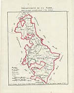
Sarre was a department in the First French Republic and First French Empire. Its territory is now part of Germany and Belgium. Named after the river Saar (French: Sarre), it was created in 1798 in the aftermath of the Treaty of Campo Formio of 18 October 1797 which ceded the left bank of the Rhine to France. Despite its name it covered a much larger area than the historical area known as the Saarland. Prior to the French occupation of the area from 1793 onward, its territory had been divided between the Electorate of Trier, Nassau-Saarbrücken and the Electorate of the Palatinate (the Duchy of Zweibrücken and the County of Veldenz). Its territory is now part of the German states Rhineland-Palatinate and Saarland as well as a tiny adjacent section of the Belgian province of Liège. Its capital was Trier. The department was subdivided into the following arrondissements and cantons (situation in 1812): Trier (French: Trèves), cantons Bernkastel, Büdlich, Konz, Pfalzel, Saarburg, Schweich, Trier and Wittlich. Birkenfeld, cantons: Baumholder, Birkenfeld, Grumbach, Hermeskeil, Herrstein, Kusel, Meisenheim, Rhaunen and Wadern. Prüm, cantons: Blankenheim, Daun, Gerolstein, Kyllburg, Lissendorf, Manderscheid, Prüm, Reifferscheid and Schönberg. Saarbrücken (French: Sarrebrück), cantons: Blieskastel, Lebach, Merzig, Ottweiler, Saarbrücken, Sankt Wendel and Waldmohr.Its population in 1812 was 277,596, and its area was 493,513 hectares (1,219,500 acres).After Napoleon was defeated in 1814, most of the department became part of Prussia, with smaller parts assigned to Duchy of Oldenburg (Birkenfeld) and Bavaria. The cantons of Sankt Wendel and Baumholder were given to Saxe-Coburg-Saalfeld as the Principality of Lichtenberg, which was sold to Prussia in 1834. The canton of Meisenheim was given to Hesse-Homburg, which was annexed to Prussia in 1866. France retained Saarbrücken but, after Waterloo, it was punished and it lost the town together with Saarlouis from nearby Moselle. The former Schönberg canton would later be included in the Eupen-Sankt Vith-Malmedy plebiscite area following World War I.