Wych Brook
Dee catchmentRivers of CheshireRivers of ShropshireRivers of Wrexham County BoroughUse British English from December 2016

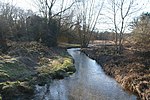
The Wych Brook, Worthenbury Brook and Red Brook, formerly known as the River Elfe, is a tributary of the River Dee in England and Wales, forming part of both the historic and present-day border between the two countries. The stream forms part of the border between Cheshire and Shropshire in England to the east, and Wales, particularly the Maelor Saesneg (a detached portion of Historic Flintshire, now within Wrexham County Borough), to the west.
Excerpt from the Wikipedia article Wych Brook (License: CC BY-SA 3.0, Authors, Images).Wych Brook
Lane End Farm Lane,
Geographical coordinates (GPS) Address Nearby Places Show on map
Geographical coordinates (GPS)
| Latitude | Longitude |
|---|---|
| N 53.038611111111 ° | E -2.8616666666667 ° |
Address
Wern-y-Davy Land Drainage Pumping Station
Lane End Farm Lane
SY14 7BW , Shocklach Oviatt and District
England, United Kingdom
Open on Google Maps


