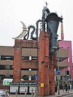
Piccadilly Gardens
1775 establishments in EnglandGardens in Greater ManchesterPiccadilly GardensSquares in ManchesterTadao Ando buildings ... and 2 more
Tourist attractions in ManchesterUse British English from March 2017

Piccadilly Gardens is a green space in Manchester city centre, England, on the edge of the Northern Quarter. It takes its name from the adjacent street, Piccadilly, which runs across the city centre from Market Street to London Road. The gardens also contain a bus station and a tram stop. Piccadilly Gardens were laid out after World War I on the former site of the Manchester Royal Infirmary. Originally landscaped as an ornamental sunken garden, the area was levelled out and reconfigured in 2002 with a water feature and concrete pavilion by Japanese architect Tadao Ando.
Excerpt from the Wikipedia article Piccadilly Gardens (License: CC BY-SA 3.0, Authors, Images).Piccadilly Gardens
Piccadilly, Manchester City Centre
Geographical coordinates (GPS) Address Nearby Places Show on map
Geographical coordinates (GPS)
| Latitude | Longitude |
|---|---|
| N 53.481111111111 ° | E -2.2372222222222 ° |
Address
Piccadilly
M1 1LS Manchester, City Centre
England, United Kingdom
Open on Google Maps


