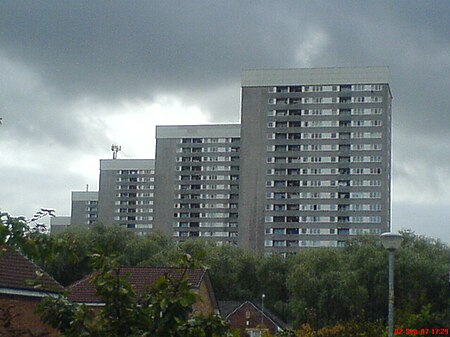
Kennishead
Areas of GlasgowGlasgow geography stubsUse British English from May 2015

Kennishead (Scots: Kennisheid, Scottish Gaelic: Ceann Ceanais) is a neighbourhood in the Scottish city of Glasgow. Its territory, south of the River Clyde, is fairly isolated, bordering a park to the south and a golf course to the north, as well as the residential area of Carnwadric. The majority of the housing consists of three (originally five, two since demolished) high rise tower blocks of 23 storeys, which dominate the area visually.The area is also home to the disused farm from which it takes its name, formerly owned by Sir John Maxwell. Kennishead was originally called "Kenneth's Head".Kennishead railway station is on the Glasgow South Western Line to Barrhead.
Excerpt from the Wikipedia article Kennishead (License: CC BY-SA 3.0, Authors, Images).Kennishead
Glasgow Kennishead
Geographical coordinates (GPS) Address Nearby Places Show on map
Geographical coordinates (GPS)
| Latitude | Longitude |
|---|---|
| N 55.813079 ° | E -4.323476 ° |
Address
G46 8RZ Glasgow, Kennishead
Scotland, United Kingdom
Open on Google Maps


