place

Ward's Reservoir

Buildings and structures in Blackburn with DarwenReservoirs in Lancashire
Ward's Reservoir geograph.org.uk 1091712

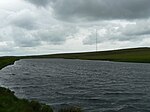
Ward's Reservoir (or Wards Reservoir), known locally as the Blue Lagoon, is a small reservoir close to the village of Belmont, Lancashire, England. It is in the West Pennine Moors north of Bolton.The reservoir did not supply drinking water but was built to supply water to Rycroft Works in the early 19th century. It was enlarged in 1893 by Deacons who used the water to supply Belmont Bleachworks. It holds 150,000 cubic metres of water, with a surface area of 28,000 square metres, when full. Most of the reservoir is only a few feet deep, but it has a depth of about 80 feet (24 m) at its deepest point.The reservoir was drained by its owner, Belmont Holdings, in 2010, despite efforts by local residents to save it. It had fallen into a state of disrepair following the closure of the bleachworks, and was considered a flood risk by the Environment Agency.By the end of August 2010 heavy rain had refilled the reservoir, and in September 2010 it was sold for £50,000. The buyer is thought to be a Horwich-based consortium who will renovate and develop the reservoir for recreational use.

Excerpt from the Wikipedia article Ward's Reservoir (License: CC BY-SA 3.0, Authors, Images).

Ward's Reservoir
Rivington Road,

Geographical coordinates (GPS) Address Nearby Places
placeShow on map

Wikipedia: Ward's ReservoirContinue reading on Wikipedia

Geographical coordinates (GPS)

Latitude Longitude
N 53.638055555556 ° E -2.5005555555556 °
placeShow on map

Address

Rivington Road

Rivington Road
BL7 8BA , North Turton
England, United Kingdom
mapOpen on Google Maps

Ward's Reservoir geograph.org.uk 1091712
Share experience

Nearby Places

Winter Hill (North West England)

Winter Hill is a hill on which the three boroughs of Chorley, Blackburn with Darwen and Bolton meet, in the historic county of Lancashire in North West England. It is located on Rivington Moor, Chorley and is 1,496 feet (456 m) high. Part of the West Pennine Moors, it is a popular walking area, and has been the site of mining activity, aeroplane disasters and murders. Its prominent position made it the ideal site for the Winter Hill TV Mast, transmitting to a large part of North West England. There is also a number of other telecommunication masts and towers around the summit and side of the hill for mobile phones, Professional Mobile Radio users and emergency services. Lancashire Constabulary was the first to use the site for one of their base stations in 1950; they had to build the road and it is said to have been built by policemen.Paths to the summit lead from Belmont (in Blackburn with Darwen), Rivington (in Chorley borough), and Horwich and Blackrod (in Bolton borough). The summit can also be reached via a short walk from the top of a road pass 1+1⁄4 miles (2 km) west of Belmont. The hill is a prominent feature on the skyline for most of the borough of Chorley and further afield. Winter Hill's topographic prominence results in it being classified as a Marilyn. The trig point on its summit marks the highest point in Blackburn with Darwen whereas the highest point in the Metropolitan Borough of Bolton is 440 yards (400 m) away on its south east slope at 1,467 feet (447 m) above sea level. It offers views over Lancashire, Cheshire, Merseyside and the Greater Manchester Urban Area, including Manchester city centre, Salford, Werneth Low, Wigan and Bolton. In clear weather conditions, it also offers views of Blackpool Tower, the Dream in Sutton, St Helens, Jodrell Bank Observatory, Snaefell in the Isle of Man, the Cumbrian mountains, Snowdonia in North Wales, Liverpool, Southport, the Irish Sea, the Pennines and much of the North West of England. On a clear day the summit offers a view of four national parks: the Lake District, Yorkshire Dales, Peak District and Snowdonia.