place

Connecticut panhandle
Border irregularities of the United StatesBorders of ConnecticutConnecticut geography stubsDarien, ConnecticutGeography of Dutchess County, New York
Geography of Fairfield County, ConnecticutGeography of Putnam County, New YorkGeography of Stamford, ConnecticutGeography of Westchester County, New YorkGreenwich, ConnecticutNew Canaan, ConnecticutNorwalk, Connecticut
Ctpanhandle
Ctpanhandle

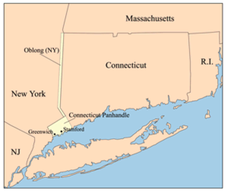
The Connecticut panhandle is the southwestern appendage of Connecticut, where it abuts New York State. It is contained entirely in Fairfield County and includes all of Greenwich, Stamford, New Canaan, and Darien, as well as parts of Norwalk and Wilton. It has some of the most expensive residential real estate in the United States. The irregularity in the boundary is the result of territorial disputes in the late 17th century, culminating with New York giving up its claim to this area, whose residents considered themselves part of Connecticut. In exchange, New York received an equivalent area extending northwards from Ridgefield, Connecticut, to the Massachusetts border, as well as undisputed claim to Rye, New York.The two British colonies negotiated an agreement on November 28, 1683, establishing the New York–Connecticut border as 20 miles (32 km) east of the Hudson River, north to Massachusetts. The 61,660 acres (249.5 km2) east of the Byram River making up the Connecticut panhandle were granted to Connecticut, in recognition of the wishes of the residents. In exchange, Rye was granted to New York, along with a 1.81-mile (2.91 km) wide strip of land known as the "Oblong" running north from Ridgefield to Massachusetts, alongside the New York counties of Westchester, Putnam, and Dutchess.

Excerpt from the Wikipedia article Connecticut panhandle (License: CC BY-SA 3.0, Authors, Images).

Connecticut panhandle
Merritt Parkway,

Geographical coordinates (GPS) Address Nearby Places
placeShow on map

Wikipedia: Connecticut panhandleContinue reading on Wikipedia

Geographical coordinates (GPS)

Latitude Longitude
N 41.117 ° E -73.499 °
placeShow on map

Address

Merritt Parkway

Merritt Parkway
06907
Connecticut, United States
mapOpen on Google Maps

Ctpanhandle
Ctpanhandle
Share experience

Nearby Places

Waveny Park
Waveny Park

Waveny Park (also known as Waveny House) is a park in New Canaan, Connecticut. The park's centerpiece is "the castle" built in 1912 and surrounded by 300 acres (1.2 km2) of fields, ponds and trails. The architect for the structure was William Tubby. Landscape design for the original residence was by landscape architect Frederick Law Olmsted, Jr. The property was listed on the National Register of Historic Places in 2019. The house was used for exterior shots for the fictional 'Cortlandt Manor' on the soap opera All My Children for many years; exteriors of the estate were also used in the 2004 remake film The Stepford Wives. The park is bordered by Farm Road to the North, the Merritt Parkway to the South, South Avenue to the East and Lapham Road to the West. Over the years, numerous additional town structures have been built on parts of the property including New Canaan High School, Waveny LifeCare Network, an aquatic center, two public water supply towers, as well as paddle tennis courts. To be able to use some of these facilities, a nominal annual fee is charged. The Parks recreations are enjoyed by many people from all around Fairfield County. Lewis Lapham, one of the founders of Texaco and the man who built Waveny House, spent summers there with his family for many years. The Lapham family gave the Town of New Canaan most of the estate land in 1967 and sold Waveny House and its surrounding 300 acres (1.2 km2) to the Town for $1,500,000. Actor Christopher Lloyd (Back to the Future, The Addams Family), born in Stamford, CT, lived in the Waveny mansion.

Rayward–Shepherd House

The Rayward–Shepherd House, also known as Tirranna and as the John L. Rayward House, was designed by renowned architect Frank Lloyd Wright and built in New Canaan, Connecticut in 1955 for Joyce and John Rayward. Although commissioned by the Raywards, Herman R. Shepherd completed the design after purchasing it in 1964. William Allin Storrer credits Shepherd's actions with salvaging the house, repairing the poor work that Storrer attributes to John Rayward's "constant pursuit of the lowest bid." (Storrer, 411) "Tirranna" is an Australian aboriginal word meaning "running waters," an apt name for this spectacular residence. Located on a pond just off the Noroton River, it features elaborate land and water-scaping. Built of standard concrete block, glass, and Colorundum flooring, and trimmed with Philippine mahogany, most of the house conforms to a hemicycle plan. Its living/dining wing overlooks a pool which steps down to a pond and extensive landscaped gardens, designed by Frank Okamura, landscape architect for the Brooklyn Botanic Garden. Charles Middeleer, a notable local landscape architect, also contributed to the landscape design.The Rayward House includes a later (1958) extension featuring an observatory above the master bedroom dressing room, as well as a playhouse for the Raywards’ daughters, Victoria and Jennifer (1957), which echoes the hemicycle form of the main house. The site was purchased by Herman R. Shepherd in 1964. According to Storrer, after 1964, Wright's successor firm, Taliesin Associated Architects (TAA), "provided a major extension beyond the work room...." which "leads to a greenhouse with servant and guest quarters, shop and extra carport." Later work by TAA "brought about the enclosure of the space between original bedroom wing and added master bedroom wing, gaining an atrium and informal living room.... Even later, a circular deck was added above the main pool." (Storrer, 411) It had been purchased in the late 1990s by businessman Ted Stanley and his wife Vada. After Stanley's death, the property with 15-acres was put on the market in January 2017 for US$8,000,000 by his heirs. The house sold in March 2018 for a reported US$4.8 million.