Rammelsberg
Copper mines in GermanyEuropean Route of Industrial Heritage Anchor PointsGoslarLandmarks in GermanyLead mines in Germany ... and 9 more
Mining in the HarzMining museums in GermanyMuseums in Lower SaxonyShow minesSilver mines in GermanyUnderground mines in GermanyUpper Harz Water RegaleWorld Heritage Sites in GermanyZinc mines in Germany

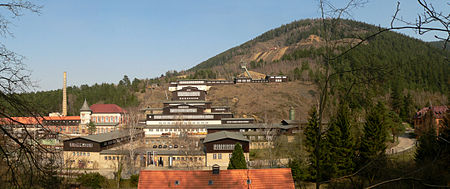
The Rammelsberg is a mountain, 635 metres (2,083 ft) high, on the northern edge of the Harz range, south of the historic town of Goslar in the North German state of Lower Saxony. The mountain is the location of an important silver, copper, and lead mine. When it closed in 1988, it had been the only mine still working continuously for over 1,000 years. Because of its long history of mining and testimony to the advancement and exchange of technology over many centuries, the visitor mine of Rammelsberg was inscribed as a UNESCO World Heritage Site in 1992.
Excerpt from the Wikipedia article Rammelsberg (License: CC BY-SA 3.0, Authors, Images).Rammelsberg
Bergtal,
Geographical coordinates (GPS) Address Website Nearby Places Show on map
Geographical coordinates (GPS)
| Latitude | Longitude |
|---|---|
| N 51.890277777778 ° | E 10.418888888889 ° |
Address
Weltkulturerbe Rammelsberg
Bergtal
38640
Lower Saxony, Germany
Open on Google Maps


