place

Pottery Lane

Former slums of LondonHistory of the Royal Borough of Kensington and ChelseaNotting HillStreets in the Royal Borough of Kensington and ChelseaUse British English from June 2015
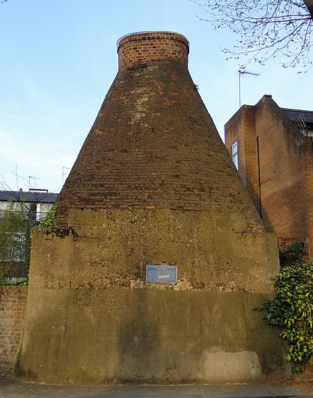
Walmer rd kiln
Walmer rd kiln

Pottery Lane is a street in Notting Hill, west London. Today it forms part of one of London's most fashionable and expensive neighbourhoods, but in the mid-19th century it lay at the heart of a wretched and notorious slum known as the "Potteries and the Piggeries". The slum came to the attention of Londoners with the building of the Hippodrome in 1837 by entrepreneur John Whyte. Unfortunately for Whyte a public right of way existed over his land and "dirty and dissolute vagabonds" from the nearby slum invaded his racecourse, adding to his financial difficulties and, in part, leading to the closure of his venture in 1842. Pottery Lane gradually improved in the late 20th century along with the rest of the Notting Hill area, and today the houses there fetch multi-million pound prices. Just one of the original brick kilns still survives; it is located in Walmer Road, just north of Pottery Lane, and bears a commemorative plaque placed there by the Royal Borough of Kensington and Chelsea.

Excerpt from the Wikipedia article Pottery Lane (License: CC BY-SA 3.0, Authors, Images).

Pottery Lane
Pottery Lane, London Notting Hill (Royal Borough of Kensington and Chelsea)

Geographical coordinates (GPS) Address Nearby Places
placeShow on map

Wikipedia: Pottery LaneContinue reading on Wikipedia

Geographical coordinates (GPS)

Latitude Longitude
N 51.5089 ° E -0.21 °
placeShow on map

Address

Pottery Lane 34
W11 4LZ London, Notting Hill (Royal Borough of Kensington and Chelsea)
England, United Kingdom
mapOpen on Google Maps

Walmer rd kiln
Walmer rd kiln
Share experience

Nearby Places

St James' Church, Norlands

St James' Church, Norlands, is a historic listed church in London, United Kingdom. It is affiliated with the Church of England. It was designed by architects Lewis Vulliamy and Robert Jewell Withers, and its construction was completed in 1845. The church was consecrated on 17 July of the same year. It is listed as Grade II by English Heritage.The church is built of white Suffolk bricks and is orientated east to west with the tower positioned south of the central bay. The entrance is through a porch, built into base of the tower, facing down Addison Avenue. The simple body of the church makes the three-stage tower, built in 1850, stand out. The first stage has gabled Buttresses with roll-moulded edges. The second stage has a clock-face set in on each side and is considerably shorter than any other stage. The final belfry stage has two deeply-recessed paired lancets flanked by single blind lancet panels. There is a drawing in Kensington Public Library which shows that the tower was designed to have been topped with a broach spire, however, this was never built, and the tower seems somewhat abrupt and unfinished without it, as the thin octagonal pinnacles on each corner stand out against the sky. Vulliamy's original design provided polygonal apsidal projections at the east and west ends, but these were never built. In 1876 the eastern end was extended by the architect, R. J. Withers. These extensions provide the present chancel, vestries and an organ chamber.The church is set in a small garden square, which is laid out in an informal style and is mainly two lawn areas with planting at the edges. The views are dominated by the mature chestnut and lime trees which surround the garden. These gardens are private and used by adjacent properties, and only open to the public occasionally.