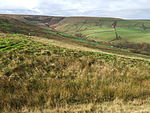
Musbury Valley
Geography of the Borough of RossendaleValleys of Lancashire

The Musbury Valley is a small valley in the Helmshore area of Rossendale Valley, Lancashire. Musbury Brook flows through its length, and its south side is flanked and dominated by Musbury Tor. In the 14th century it was part of the Earl of Lincoln's hunting park. Most of the Musbury valley is now sheep grazing pasture. To the south is Musbury Tor and Alden Valley; to the north-west is Musbury Heights and, beyond, the Grane Valley. Beginning as Long Grain Water on Musden Head Moor, the stream becomes Musbury Brook after its confluence with Short Grain Water. It flows in a north-westerly direction to join the River Ogden, a tributary of the River Irwell.
Excerpt from the Wikipedia article Musbury Valley (License: CC BY-SA 3.0, Authors, Images).Musbury Valley
Borough of Rossendale
Geographical coordinates (GPS) Address Nearby Places Show on map
Geographical coordinates (GPS)
| Latitude | Longitude |
|---|---|
| N 53.686 ° | E -2.353 ° |
Address
Musbury Park Moor
BB4 4AL Borough of Rossendale
England, United Kingdom
Open on Google Maps


