place

Skirlaugh

Civil parishes in the East Riding of YorkshireHoldernessOpenDomesdayUse British English from January 2014Villages in the East Riding of Yorkshire
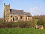
St Augustine's Church, Skirlaugh geograph.org.uk 551356

Skirlaugh is a village and civil parish in the East Riding of Yorkshire, England, in an area known as Holderness. It is situated approximately 7 miles (11 km) north-east of Hull city centre on the A165 road. Originally a farming community, it is now primarily a commuter village for Hull. The name of the village is derived from Old English and originally meant shire clearing. The name is partly due to Old Norse influence, as the village lies in the former Danelaw; it is identical in meaning to Shirley.According to the 2011 UK census, Skirlaugh parish had a population of 1,473, a decrease on the 2001 UK census figure of 1,543. The parish church, St Augustine's Church, was built by Walter de Skirlaw who later became the Bishop of Durham in the late 14th century. It is, according to Pevsner, a "gem of the early-perpendicular" style. This is because subsequent generations left the original structure largely intact. The stonework was re-pointed in the 1980s and 1990s by Edward Brown, a local volunteer. The church is a Local Ecumenical Partnership between the Church of England and the Methodist church. In 1966 the church was designated a Grade I listed building and is now recorded in the National Heritage List for England, maintained by Historic England. Skirlaugh was served from 1864 to 1957 by Skirlaugh railway station on the Hull and Hornsea Railway even though the station was located 1.5 miles (2.4 km) south of the village.Skirlaugh rugby league club, play in the Premier Division of the National Conference League.

Excerpt from the Wikipedia article Skirlaugh (License: CC BY-SA 3.0, Authors, Images).

Geographical coordinates (GPS)

Latitude Longitude
N 53.840079 ° E -0.267274 °
placeShow on map

Address

Main Road

Main Road
HU11 5BA , Skirlaugh
England, United Kingdom
mapOpen on Google Maps

St Augustine's Church, Skirlaugh geograph.org.uk 551356
Share experience

Nearby Places

Benningholme
Benningholme

Benningholme is a hamlet in the East Riding of Yorkshire, England, in an area known as Holderness. It is situated approximately 6 miles (10 km) north of Hull city centre and 1 mile (1.6 km) south-west of the village of Skirlaugh. It forms part of the civil parish of Swine. Benningholme is listed in the Domesday Book as "Benicol" and "Benincol". It was within the Holderness Middle Hundred of the East Riding of Yorkshire. The hall and manor comprised 29 villagers, 5 smallholders. 6 freemen and 4 men-at-arms, with 53 ploughlands, woodland, and 274 acres (1.1 km2) of meadow. At the Norman Conquest Ulf Fenman was the lord, this transferred in 1086 to Drogo de la Beuvriere, who also became Tenant-in-chief.Benningholme is the site of a deserted medieval village (DMV), near Benningholme Grange (farm), and Benningholme Hall. In 1571 an enclosure was noted. The deserted settlement is defined by now hardly discernible earthworks.In 1899 Benningholme, as part of the township of Benningholme-with-Grange, was within the parish of Skirlaugh. Benningholme township land was owned by The Crown, which was also the lord of the manor. Chief crops grown in the parish were wheat, oats, turnips, beans and seeds, within an area of 1,470 acres (6 km2). Benningholme's population in 1891 was 88. Post was directed through Hull, being collected from and distributed to Skirlaugh by foot messenger. Skirlaugh contained the nearest money order and telegraph office.A half-mile (800 metres) to the east of Benningholme is the Grade II listed Benningholme Hall, an 1820–30 late Georgian house. Built of grey gault brick, it is of a five-bay and two-storey construction with a hipped roof of Welsh slate. The central entrance is surrounded by a portico with an entablature supported by columns of ionic style. At the rear of the building is an iron veranda along its length, with a bow structure part enclosing a garden below. Attached to the original house is a 20th-century extension.

Long Riston
Long Riston

Long Riston is a village in the civil parish of Riston, in the East Riding of Yorkshire, England, in an area known as Holderness. It is situated approximately 9 miles (14 km) north of Kingston upon Hull city centre and 6 miles (10 km) east of Beverley town centre. It lies to the east of the A165 road which by-passes the village. In 1931 the parish had a population of 266. On 1 April 1935 the parish was abolished to form Riston.The church dedicated to St Margaret was designated a Grade II* listed building in 1966 and is now recorded in the National Heritage List for England, maintained by Historic England.The village is a commuter settlement for those working in Hull and Beverley. The village has one public house, The Micro Pig. In 1823 Long Riston was a civil parish in the Wapentake and Liberty of Holderness. Population at the time was 361. Occupations included eight farmers, two blacksmiths, three grocers, two shoemakers, two tailors, two wheelwrights, a butcher, a bricklayer, a hawker, and the landlord of The Traveller public house. Two carriers operated between the village and Hull, and Beverley, twice weekly.In 1872 land adjacent to Main Street was given for the establishment of a school. The school was completed in March 1873. Until the late 1950s it was known as Long Riston School and served both Long Riston and the hamlet of Arnold. Subsequently, it became known as Riston C E Primary School. The school is a voluntary controlled church school in the diocese of York. The church stands back from the road in fields at the north end of the village that show signs of medieval ridge and furrow farming and next to an area called Butt Hills that seems to hint at more history as these are in the right place for and carry the right name for medieval Archery Butts. Long Riston Archery Festival has been held yearly since 2013 in the Medieval archery butts next to St Margaret's church, Long Riston.