place

Heptapyrgion (Thessaloniki)

Buildings and structures in ThessalonikiByzantine fortifications in GreeceCastles in GreeceOttoman architecture in ThessalonikiOttoman fortifications in Greece
Prisons in Greece
THES Heptapyrgion location

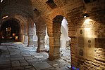
The Heptapyrgion (Medieval Greek: Ἑπταπύργιον, [heptaˈpyrgion]), modern Eptapyrgio (Greek: Επταπύργιο, [eptaˈpirʝio]), also popularly known by its Ottoman Turkish name Yedi Kule (Γεντί Κουλέ), is a Byzantine and Ottoman-era fortress situated on the north-eastern corner of the Acropolis of Thessaloniki in Greece. Despite its name, which in both languages means "Fortress of Seven Towers", it features ten, and was probably named after the Yedikule Fortress in Constantinople (modern Istanbul, Turkey). It served as the major redoubt of the city's acropolis, as well as the seat of its garrison commander in Ottoman times, until the late 19th century. It was then converted to a prison (Φυλακές Επταπυργίου), which remained open until 1989. References to the infamous Yedi Kule prison abound in the Greek rebetika songs. Restoration and archaeological work began in the 1970s and continues to this day.

Excerpt from the Wikipedia article Heptapyrgion (Thessaloniki) (License: CC BY-SA 3.0, Authors, Images).

Heptapyrgion (Thessaloniki)
Παπαρέσκα, Thessaloniki Municipal Unit Άνω Πόλη (3rd District of Thessaloniki)

Geographical coordinates (GPS) Address External links Nearby Places
placeShow on map

Wikipedia: Heptapyrgion (Thessaloniki)Continue reading on Wikipedia

Geographical coordinates (GPS)

Latitude Longitude
N 40.644 ° E 22.962 °
placeShow on map

Address

Επταπύργιο (Γεντί Κουλέ)

Παπαρέσκα
554 38 Thessaloniki Municipal Unit, Άνω Πόλη (3rd District of Thessaloniki)
Macedonia and Thrace, Greece
mapOpen on Google Maps

linkWikiData (Q1572213)
linkOpenStreetMap (978511541)

THES Heptapyrgion location
Share experience

Nearby Places

Paleochristian and Byzantine monuments of Thessaloniki

The city of Thessaloniki in Macedonia, Greece, for several centuries the second-most important city of the Byzantine Empire, played an important role for Christianity during the Middle Ages and was decorated by impressive buildings. Because of Thessaloniki's importance during the early Christian and Byzantine periods, the city contains several Paleochristian monuments that have significantly contributed to the development of Byzantine art and architecture throughout the Byzantine Empire and Serbia. The evolution of Imperial Byzantine architecture and the prosperity of Thessaloniki go hand in hand, especially during the first years of the Empire, when the city continued to flourish. Despite the capture of Thessaloniki by the Ottoman Empire in 1430, the Christian monuments were not destroyed, and travelers such as Paul Lucas and Abdulmejid I document the city's wealth in Christian monuments during the Ottoman control of the city. In 1988, fifteen monuments of Thessaloniki were listed as UNESCO World Heritage Sites: City Walls (4th/5th centuries) Rotunda of Saint George (4th century) Church of Acheiropoietos (5th century) Church of St. Demetrios (7th century) Latomou Monastery (6th century) Church of St. Sophia (8th century) Church of Panagia Chalkeon (11th century) Church of St. Panteleimon (14th century) Church of the Holy Apostles (14th century) Church of St. Nicholas Orphanos (14th century) Church of St. Catherine (13th century) Church of Christ Saviour (14th century) Blatades Monastery (14th century) Church of Prophet Elijah (14th century) Byzantine Bath (14th century)

Icon of Christ of Latomos

The Icon of Christ of Latomos (or Latomou), also known as the Miracle of Latomos, is a Byzantine-style mosaic of Jesus in the monastery of Latomos (now the Church of Hosios David the Dendrite) in Thessaloniki, Greece, that is an acheiropoieton (a religious image that is believed to have been made miraculously). The origins of this mosaic icon can be traced back to the late third century AD when Maximian and Diocletian reigned jointly over the Roman Empire. The Icon of Christ of Latomos is one of the lesser-known acheiropoieta (Greek: αχειροποίητα εικόνα).According to tradition, the Icon of Christ of Latomos was discovered by Princess Flavia Maximiana Theodora, the Christian daughter of Emperor Maximian. She hid it to protect it from potential damage by the pagan, Roman authorities, and it remarkably survived Byzantine iconoclasm in the eighth century as well as a period of time in the fifteenth century when the church of Hosios David was converted to an Islamic mosque (during the Ottoman occupation of Thessaloniki). Sometime before the Ottoman occupation and prior to the twelfth century, the mosaic icon was rediscovered by a monk from Lower Egypt. It was again rediscovered in 1921, at which time the building was reconsecrated to Saint David.Thematically and artistically, the Icon of Christ of Latomos is likely the first of its type, depicting an apocalyptic scene with imagery from the Book of Ezekiel which communicates important theological ideas about the apocalypse.

Upper Town (Thessaloniki)

Thessaloniki's Upper Town called Ano Poli (Greek: Άνω Πόλη, [ˈano ˈpoli]) is the old town of Thessaloniki and is located around the city's acropolis north of the city center. The neighborhood is known for its well preserved Byzantine and Ottoman era structures and urban design and as a center for Thessaloniki's poets, intellectuals, and bohemians. Ano Poli is one of the most traditional areas in Thessaloniki. The area preserves much of the Byzantine and Ottoman era city design which was largely destroyed elsewhere in the city in the Great Fire of 1917. It is known for its small stone-paved streets, old squares, and houses in traditional Greek and Ottoman architecture. Ano Poli is the highest part of the city and is dominated by the city's acropolis, a Byzantine and Ottoman era fort known as the Eptapyrgio. What remains of the old city walls still surround Ano Poli and many Ottoman and Byzantine structures such as the church of Profitis Elias, the Church of Saint Nicholas Orphanos, the Taxiarches church, the Byzantine bath, the Church of Saint Catherine, the Vlatades Monastery, the Atatürk Museum, and the Alaca Imaret Mosque still stand in the neighborhood. Other landmarks include the buildings of Villa Moskof and Villa Varvara. During the Ottoman period Ano Poli was the main district for the Turks (Muslims) of the city while Greeks, western Europeans, and Jews lived below around the port. On clear days Mount Olympus, about 80 km (50 mi) away across the gulf, can also be seen towering the horizon.

Byzantine Bath (Thessaloniki)

The Byzantine Bath of the Upper Town (Greek: Βυζαντινά Λουτρά Άνω Πόλης, Vyzantiná Loutrá Áno Pólis) in Thessaloniki is one of the few and best preserved of the Byzantine baths that have survived from the Byzantine period in Greece. It is located on the Theotokopoulou Street in the Upper Old Town of Thessaloniki.The baths date to the late 12th/early 13th century, and functioned continuously until 1940, when they shut down probably due to World War II and the German occupation of Greece. The Byzantine sources do not mention it, hence it is likely that it originally belonged to a monastery complex. In Ottoman times, it was known as Kule Hammam, i.e. "bath of the citadel".The bath's long use led to numerous alterations of the original structure over time. The original architecture follows the typical conventions of Roman baths. The original entrance in the south leads to the rectangular frigidarium rooms, which were used as dressing rooms. Then came two vaulted tepidarium rooms and finally two caldarium rooms. The latter were square in shape and featured hypocausts below the floor. One was covered by a dome supported by an octagonal base with eight windows, the other had a domed ceiling. To the north of the baths was the cistern that provided it with water, with a hearth beneath to warm it. In Byzantine times the building was alternately used by men and women, but in the Ottoman period the bath was divided into exclusively male and female sections, by blocking off each pair of rooms from each other.The bath was one of several in the city—the 14th-century writer Nikephoros Choumnos claims that Thessaloniki had more baths than inhabitants—but is the only surviving in Thessaloniki and the largest and most complete of the handful of Byzantine baths surviving elsewhere in Greece: five ruined public baths—two in Corinth, one in Sparta, one in Paramythia, one in Ioannina Castle—and one each in the monasteries of Kaisariani and Zoodochos Pigi.Although closed since 1940, the bath was subject to neglect and damage during the 1978 earthquakes, and only survived standing through heavy propping up by the 9th Ephorate of Byzantine Antiquities and the protection offered by an external metal sheet covering. In 1988, it was included among the Paleochristian and Byzantine monuments of Thessaloniki on the list of World Heritage Sites by UNESCO.Following four years of restoration work, the bath was re-opened to the public as a museum and cultural space in June 2015.