place

Pammegistoi Taxiarches church

14th-century churches in Greece14th-century establishments in the Byzantine EmpireBasilica churches in GreeceByzantine church buildings in ThessalonikiFormer mosques in Greece
Infobox religious building with unknown affiliationMosques converted from churches in Ottoman Greece
Ναός Παμμεγίστων Ταξιαρχών, Θεσσαλονίκη 1921

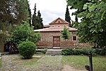
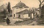
The Pammegistoi Taxiarches church (Greek: Ιερός Ναός Παμμεγίστων Ταξιαρχών, lit. 'Holy Church of the All-Great Taxiarchs') is a Byzantine church located in the Upper Town of Thessaloniki, Greece. The church was built in the 14th century, and served as a mosque during the Ottoman period, before it was turned back into a church in 1912. The church underwent significant modifications during the 1950s and the 1960s, and unlike other Byzantine churches in Thessaloniki, a new section was added in neo-Byzantine style.

Excerpt from the Wikipedia article Pammegistoi Taxiarches church (License: CC BY-SA 3.0, Authors, Images).

Pammegistoi Taxiarches church
Μουσών, Thessaloniki Municipal Unit Άνω Πόλη (3rd District of Thessaloniki)

Geographical coordinates (GPS) Address Nearby Places
placeShow on map

Wikipedia: Pammegistoi Taxiarches churchContinue reading on Wikipedia

Geographical coordinates (GPS)

Latitude Longitude
N 40.639805555556 ° E 22.954694444444 °
placeShow on map

Address

Ιερός Ναός Ταξιαρχών

Μουσών
546 34 Thessaloniki Municipal Unit, Άνω Πόλη (3rd District of Thessaloniki)
Macedonia and Thrace, Greece
mapOpen on Google Maps

Ναός Παμμεγίστων Ταξιαρχών, Θεσσαλονίκη 1921
Share experience

Nearby Places

Byzantine Bath (Thessaloniki)

The Byzantine Bath of the Upper Town (Greek: Βυζαντινά Λουτρά Άνω Πόλης, Vyzantiná Loutrá Áno Pólis) in Thessaloniki is one of the few and best preserved of the Byzantine baths that have survived from the Byzantine period in Greece. It is located on the Theotokopoulou Street in the Upper Old Town of Thessaloniki.The baths date to the late 12th/early 13th century, and functioned continuously until 1940, when they shut down probably due to World War II and the German occupation of Greece. The Byzantine sources do not mention it, hence it is likely that it originally belonged to a monastery complex. In Ottoman times, it was known as Kule Hammam, i.e. "bath of the citadel".The bath's long use led to numerous alterations of the original structure over time. The original architecture follows the typical conventions of Roman baths. The original entrance in the south leads to the rectangular frigidarium rooms, which were used as dressing rooms. Then came two vaulted tepidarium rooms and finally two caldarium rooms. The latter were square in shape and featured hypocausts below the floor. One was covered by a dome supported by an octagonal base with eight windows, the other had a domed ceiling. To the north of the baths was the cistern that provided it with water, with a hearth beneath to warm it. In Byzantine times the building was alternately used by men and women, but in the Ottoman period the bath was divided into exclusively male and female sections, by blocking off each pair of rooms from each other.The bath was one of several in the city—the 14th-century writer Nikephoros Choumnos claims that Thessaloniki had more baths than inhabitants—but is the only surviving in Thessaloniki and the largest and most complete of the handful of Byzantine baths surviving elsewhere in Greece: five ruined public baths—two in Corinth, one in Sparta, one in Paramythia, one in Ioannina Castle—and one each in the monasteries of Kaisariani and Zoodochos Pigi.Although closed since 1940, the bath was subject to neglect and damage during the 1978 earthquakes, and only survived standing through heavy propping up by the 9th Ephorate of Byzantine Antiquities and the protection offered by an external metal sheet covering. In 1988, it was included among the Paleochristian and Byzantine monuments of Thessaloniki on the list of World Heritage Sites by UNESCO.Following four years of restoration work, the bath was re-opened to the public as a museum and cultural space in June 2015.

Upper Town (Thessaloniki)

Thessaloniki's Upper Town called Ano Poli (Greek: Άνω Πόλη, [ˈano ˈpoli]) is the old town of Thessaloniki and is located around the city's acropolis north of the city center. The neighborhood is known for its well preserved Byzantine and Ottoman era structures and urban design and as a center for Thessaloniki's poets, intellectuals, and bohemians. Ano Poli is one of the most traditional areas in Thessaloniki. The area preserves much of the Byzantine and Ottoman era city design which was largely destroyed elsewhere in the city in the Great Fire of 1917. It is known for its small stone-paved streets, old squares, and houses in traditional Greek and Ottoman architecture. Ano Poli is the highest part of the city and is dominated by the city's acropolis, a Byzantine and Ottoman era fort known as the Eptapyrgio. What remains of the old city walls still surround Ano Poli and many Ottoman and Byzantine structures such as the church of Profitis Elias, the Church of Saint Nicholas Orphanos, the Taxiarches church, the Byzantine bath, the Church of Saint Catherine, the Vlatades Monastery, the Atatürk Museum, and the Alaca Imaret Mosque still stand in the neighborhood. Other landmarks include the buildings of Villa Moskof and Villa Varvara. During the Ottoman period Ano Poli was the main district for the Turks (Muslims) of the city while Greeks, western Europeans, and Jews lived below around the port. On clear days Mount Olympus, about 80 km (50 mi) away across the gulf, can also be seen towering the horizon.

National Map Library

The National Map Library (Greek: Εθνική Χαρτοθήκη), properly the National Centre for Maps and Cartographic Heritage - National Map Library, is located in Thessaloniki, Central Macedonia, Greece. It was established in 1997 (Law 2466/1997) for the purpose of preserving, archiving, conserving, promoting, and displaying maps, studying the educational, cultural, and social role of maps, collaborating at a scientific and technical level with national and international organizations, organizing permanent and mobile exhibitions accompanied by catalogues, utilising public and private map collections, and organising seminars and conferences. Since February 1999 the National Map Library has been housed in a two-storey listed building in the Upper Town (Ano Poli). On the ground floor are the scientific and administrative departments and on the first floor there is a permanent exhibition space which hosts frequent cartographic exhibitions. There is an archive of 1,000 maps, which are being electronically documented and archived with the help of a special database. Between 1 and 12 November 1999, there was an exhibition of six 19th-century cartoon maps of Europe, five children's maps which had been entered for the international cartographic competition in 1999, and some rare maps drawn by Sotiris Zissis, a self-taught Thessalonian cartographer. Other exhibitions organised by the National Map Library include History in Maps at the Residency, Maps of Ports of Greek Cities of the Twentieth Century in the National Research Institute, and Greek Cartography in Thessaloniki in the Twentieth Century. An educational programme titled The National Map Library Meets Teachers and Children has been drawn up and is addressed to schools in Macedonia and Thrace.