Al-Burj, Ramle
Arab villages depopulated during the 1948 Arab–Israeli WarDistrict of RamlaPages with non-numeric formatnum arguments

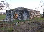
Al-Burj (Arabic: البرج) was a Palestinian Arab village 14 km east of Ramle close to the highway to Ramallah, which was depopulated in 1948. Its name, "the tower", is believed to be derived from the crusader castle, Castle Arnold, built on the site. Victorian visitors in the 19th century recorded seeing crusader ruins close to the village.
Excerpt from the Wikipedia article Al-Burj, Ramle (License: CC BY-SA 3.0, Authors, Images).Al-Burj, Ramle
Emek Dotan, Modiin-Maccabim-Reut HaNehalim
Geographical coordinates (GPS) Address Nearby Places Show on map
Geographical coordinates (GPS)
| Latitude | Longitude |
|---|---|
| N 31.901944444444 ° | E 35.020555555556 ° |
Address
גבעת התיתורה
Emek Dotan
7173709 Modiin-Maccabim-Reut, HaNehalim
Center District, Israel
Open on Google Maps


