East Wheal Rose

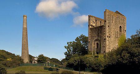
East Wheal Rose was a metalliferous mine around three-quarters of a mile (1.2 km) south east of the village of St Newlyn East and is around 4 miles (6.4 km) from Newquay on the north Cornwall coast, United Kingdom. The country rock at the mine was killas and its main produce was lead ore (galena), but as is usual when mining this mineral, commercial quantities of silver and zinc were also found and sold. Lead was found in the area in 1812 and in 1834 the mine was established, by 1846 the mine employed over 1,200 men, women and children.The two main lodes, called Middleton's Lode and East Lode, trended north-south. The ore they contained was in places very soft and loose and the killas was also not a particularly strong rock, necessitating extensive underground timbering, particularly in the shafts. Records show that the mine had more than twenty shafts on the two lodes, and the deepest workings were at 150 fathoms (900 ft).
Excerpt from the Wikipedia article East Wheal Rose (License: CC BY-SA 3.0, Authors, Images).East Wheal Rose
Mitchell Lane,
Geographical coordinates (GPS) Address Nearby Places Show on map
Geographical coordinates (GPS)
| Latitude | Longitude |
|---|---|
| N 50.362 ° | E -5.041 ° |
Address
Mine Engine House
Mitchell Lane
TR8 5JF
England, United Kingdom
Open on Google Maps


