place

Maaria

AC with 0 elementsFormer municipalities of FinlandHistory of TurkuWestern Finland Province geography stubs
Maaria.vaakuna
Maaria.vaakuna

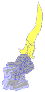
Maaria (S:t Marie in Swedish) is a former municipality of Finland in what is now the northern part of the city of Turku. The area has been inhabited since the Iron Age, and it became an important village in the 15th century with the construction of a church dedicated to the Virgin Mary (hence the district's name). Also Koroinen, with the former residence of the Bishop of Finland is in the area. The municipality of Maaria was founded in 1868, and it included the northern parts of modern Turku south of Paattinen, some enclaves to the north of Paattinen, and the island of Hirvensalo to the south of Turku. In 1944, Hirvensalo, Raunistula and some other parts of the municipality were annexed into Turku, and the rest of the municipality followed suit in 1967. Since then, it has seen considerable growth. The Maaria Reservoir, which serves as an alternative source of tap water for Turku, was constructed in the area in 1982. The area that used to be central Maaria is currently divided into the districts of Jäkärlä, Saramäki, Turku Airport and Yli-Maaria. The former municipality's name is preserved in administrative units such as the parish of Maaria, the district of Yli-Maaria and the ward of Maaria-Paattinen, which includes the five northern districts of Turku.

Excerpt from the Wikipedia article Maaria (License: CC BY-SA 3.0, Authors, Images).

Maaria
Suvannontie, Turku Paimala (Maaria-Paattinen)

Geographical coordinates (GPS) Address Nearby Places
placeShow on map

Wikipedia: MaariaContinue reading on Wikipedia

Geographical coordinates (GPS)

Latitude Longitude
N 60.533333333333 ° E 22.333333333333 °
placeShow on map

Address

Suvannontie

Suvannontie
20460 Turku, Paimala (Maaria-Paattinen)
Finland
mapOpen on Google Maps

Maaria.vaakuna
Maaria.vaakuna
Share experience

Nearby Places

Old Castle of Lieto
Old Castle of Lieto

Old Castle of Lieto (Finnish: Liedon Vanhalinna) is a site of a hillfort in Lieto, Finland. It rises 55 meters above the sea level.The original name of the castle is not known. According to excavations, the castle has been in use three times during its history, in the Late Bronze Age (1100–500 BCE) and in Middle Iron Age (500–700 CE). The third phase of the site between years 1000-1370 can be divided into two. According to the excavations the years 1000–1150 are marked with German money and prehistoric artefacts and the years 1200–1370 with Scandinavian bracteates and medieval artefacts. The hillfort was used by the local Finns proper population until 1170, when it was conquered most likely by the Swedes who possibly used it as a stronghold against Tavastians. The steep hillside supported by fortifications on top of the hill provided a good defensive position. Constructions on the hillfort were mostly made of wood. In the latest phase bricks were used as well. Remains of 11 buildings have been found from the top of the hillfort. Earliest defensive structures have been dated to 500 BCE and an outer bailey was in use in the Middle Ages. Total of 14 arrowheads and 150 crossbow bolt heads have been found from the area as well as several spear heads which the oldest has been dated to 6th century. Also several traces of fire have been found from the hillfort. Earliest traces of fire have been dated to Migration Period and the latest to 1360s.The castle was located between two ancient transport routes: Aura river and Hämeen härkätie leading to central Tavastia. Its importance decreased when the Turku castle was finished in beginning of the 14th century. Hence the name Old Castle of Lieto.