place

Nempnett Thrubwell

Civil parishes in SomersetUse British English from July 2012Villages in Bath and North East Somerset
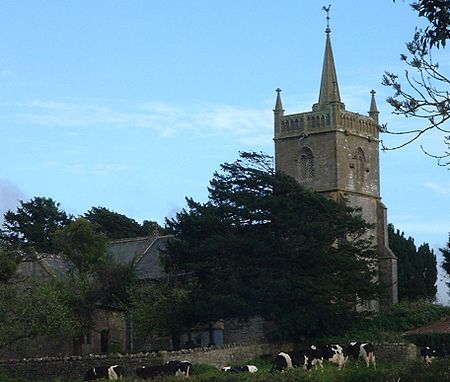
Nempnett church
Nempnett church

Nempnett Thrubwell is a small village and civil parish in dairying country on the western edge of Bath and North East Somerset, in the county of Somerset, England. It is about 15 km south-west of Bristol. The parish, which has a population of 177, is sheltered by the Mendip Hills, near the River Yeo in the Chew Valley. It is the site of the Fairy Toot oval barrow. Lying just to the north of Blagdon Lake, isolated Nempnett Thrubwell falls within the network of minor roads bounded by the A38, A368, B3114 and B3130; whilst signposted from each of these major routes, a lack of any further signposting makes it difficult to locate the village when arriving by road. The landscape is characterized by isolated farmsteads, the vernacular older buildings generally of the local Lias limestone or of render with clay-tiled roofs. Though being largely rural and consisting of one road and a few houses, Nempnett Thrubwell's curiously comedic name makes the village something of a famous local attraction. It is the subject of the song Down In Nempnett Thrubwell by The Wurzels and is mentioned in the earlier Adge Cutler song Up The Clump.

Excerpt from the Wikipedia article Nempnett Thrubwell (License: CC BY-SA 3.0, Authors, Images).

Nempnett Thrubwell
Nempnett Street,

Geographical coordinates (GPS) Address Nearby Places
placeShow on map

Wikipedia: Nempnett ThrubwellContinue reading on Wikipedia

Geographical coordinates (GPS)

Latitude Longitude
N 51.3379 ° E -2.6798 °
placeShow on map

Address

Nempnett Street
BS40 8YS
England, United Kingdom
mapOpen on Google Maps

Nempnett church
Nempnett church
Share experience

Nearby Places

Church of St Mary, Nempnett Thrubwell

The Anglican Church of St Mary stands on Knap Hill in Nempnett Thrubwell, Somerset, England dates from the 15th century, but was built on the site of an earlier Norman church. It is a Grade II* listed building,Before the dissolution of the monasteries the parish belonged to Flaxley Abbey in Gloucestershire. In 1537 the land and manor were granted to Sir William Kingston. The parish register lists christenings, marriages and burials from 1568. The three stage tower, which contains five bells, has set back buttresses and two arch bell openings with tracery. The tower is crowned by a parapet with blank arcading, and square pinnacles, it also has a slightly higher stair turret. The nave was restored at a cost of £700 in 1864. The late Victorian chancel of 1897 is in the decorated style. Inside the church is a screen attributed to Pugin, although Nikolaus Pevsner is of the opinion the architect is probably Pugin the younger.The base of a 15th-century cross in the churchyard is listed Grade II.Wade and Wade in their 1929 book "Somerset" described it as "a small building with a Perp. W. tower, from the W. face of which project two curious and uncanny carved heads of a man and beast. The walls of the nave still bear the original 13th cent. consecration crosses. The chancel is modern, and contains a rich modern screen and a good E. window of Munich glass. Note (1) rude Norm. S. doorway filled with Perp. tracery; (2) Norm. font carved with a curious device by some later craftsman. Near the porch in the churchyard is (1) base of ancient cross; (2) tomb of first rector — Robert — bearing an incised cross".

Plaster's Green Meadows

Plaster's Green Meadows (grid reference ST532611) is a 4.3 hectare biological Site of Special Scientific Interest near the village of Nempnett Thrubwell, Bath and North East Somerset, notified in 1989. This is an area of unimproved and traditionally managed species-rich meadows which support a neutral grassland community of a type which is now rare throughout Britain. The site is situated on the slopes fringing the Lias Tablelands and is underlain by Rhaetic clays and, lower down the slope Keuper Red Marl. The slowly permeable clay soils are slightly calcareous in nature and this is reflected in elements of the flora. The site is characterised by the nationally rare Common Knapweed (Centaurea nigra) and Crested Dog’s-tail (Cynosurus cristatus) and dominant grasses include Sweet Vernal-grass (Anthoxanthum odoratum), Crested Dog’s-tail and Yorkshire Fog (Holcus lanatus), while Quaking Grass (Briza media) and Yellow Oat-grass (Trisetum flavescens) are also frequent. There is a high component of herb species throughout the meadows including Saw-wort (Serratuta tinctoria), Dyer’s Greenweed (Genista tinctoria), Common Knapweed, Pepper-saxifrage (Silaum silaus), Devil’s-bit Scabious (Succisa pratensis), Betony (Stachys officinalis) and Spiny Restharrow (Ononis spinosa). The calcareous nature of the soil is reflected by the presence of Cowslip (Primula veris), Fairy Flax (Linum catharticum), Glaucous Sedge (Carex flacca), Lady’s Bedstraw (Galium verum) and occasional Salad Burnet (Sanguisorba minor). The meadows are bounded by hedges supporting numerous species including Hawthorn (Crataegus monogyna), Wych Elm (Ulmus glabra), English Elm (Ulmus procera), Hazel (Corylus avellana) and Field Maple (Acer campestre). Hedgerow trees include Ash (Fraxinus excelsior), Sweet Chestnut (Castanea sativa), Holly (Ilex aquifolium) and Oak (Quercus spp.).

Fairy Toot
Fairy Toot

The Fairy Toot is an extensive oval barrow in the civil parish of Nempnett Thrubwell, Somerset, England (grid reference ST520618). It is an example of the Severn-Cotswold tomb type which consist of precisely-built, long trapezoid earth mounds covering a burial chamber. Because of this they are a type of chambered long barrow. Fairy Toot was formerly a chambered cairn which is a Scheduled Ancient Monument. Located south-southwest of Howgrove Farm, it is a mound 60 m long, 25 m wide and now 2.5 m high, retained by a stone wall. Its summit is covered with ash trees and shrubs. Formerly it was considerably higher. On being opened and essentially destroyed between 1787 and 1835 by the Reverend Thomas Bere of Butcombe and the Reverend John Skinner of Camerton, it was found to contain two rows of cells, running from south to north, formed by immense stones set edgeways, and covered by others of larger dimensions. A human skull from the barrow is now in the Bristol Museum and Art Gallery.At the time it was conjectured to be a work of the Druids, but its origins are far older and probably date from the Neolithic period.Wade and Wade in their 1929 book "Somerset" described it as "a remarkably fine tumulus of masonry, said to have been one of the finest in Britain, in the chambers of which skeletons have been discovered. A few vestiges of it now only remain, the rest has been used as a lime-kiln."The site was visited in the past as it was known as a place for curing warts.

Church of St Michael the Archangel, Compton Martin

The Parish church of St Michael the Archangel (grid reference ST545570) is in the village of Compton Martin, Somerset, England. The church is a grade I listed building, and several of the monuments in the church yard also have listed status., The church is dedicated to St Michael the Archangel. The church, which was built in the 12th century in a Norman style funded by William FitzWalter. The tower was added in 1441. Norman vaulting can be seen in the chancel, arcades firming aisles north and south of the nave and clerestory. There is Jacobean work in choir stalls and organ screen. In the north wall is a recess containing the effigy of Thomas de Moreton which was discovered in 1858. One of the columns in the South side of the nave has an unusual spiral fluted decoration known as an apprentices column.Above the ceiling of the Bickfield Chapel there is a void which contains a columbarium or dovecote. This housed 140 “squabs” or pigeons in 1606 for the rector's table.The four stage tower is approached from the nave via a lofty Tudor paneled arch which together with the tower itself which is supported by diagonal buttresses, dates from c. 1370 or 1443. It is some 70 feet (21 m) high and contains six 18th-century bells, five of which were cast by the Bilbies of Chew Stoke. Wade and Wade in their 1929 book "Somerset" described the church as "quite remarkable" "The church is one of the finest bits of Norm. work in the county. The nave is entirely late Norm., and possesses the unusual feature of a clerestory. The fine arcades, with their cylindrical columns and circular abaci, are too obvious to escape notice, but particular attention should be paid to the twisted pillar on the N.E. The chancel has an extremely low quadripartite vault, the effect of which is rather spoilt by the distortion of the chancel arch through some defect in the foundations. The aisles are Perp., and the one on the S. curiously encloses the clerestory. Note (1) the junction of the Perp. arch and Norm. pillars, (2) recessed effigy of a lady at E. end of N. aisle, (3) semi-circular recess, probably for additional altar (cp. Cudworth); (4) Norm. font on a fluted pedestal, (5) Perp. screen, said to have been an importation. There is a Perp. W. tower of weak design and poor workmanship, opening into the nave by a panelled arch."The parish is part of the benefice of Blagdon with Compton Martin and Ubley.