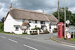
Tetcott

Tetcott is a civil parish, small settlement and former manor (once the home of the Arscotts of Tetcott) in Devon, England. The parish lies about five miles south of the town of Holsworthy and is bordered on the north by the parish of Clawton, on the east by a small part of Ashwater, and on the south by Luffincott. It forms part of the local government district of Torridge, and its western boundary is the River Tamar which forms the Cornish border. In 2001 its population was 110, half that of a century earlier (220 in 1901).The settlement of Tetcott itself consists almost solely of the manor house and parish church of Holy Cross, but there are other hamlets in the parish, the largest of which is Lana about half a mile to the south-east.
Excerpt from the Wikipedia article Tetcott (License: CC BY-SA 3.0, Authors, Images).Tetcott
Luffincott Footpath 4, Torridge District
Geographical coordinates (GPS) Address Nearby Places Show on map
Geographical coordinates (GPS)
| Latitude | Longitude |
|---|---|
| N 50.733333333333 ° | E -4.3666666666667 ° |
Address
Luffincott Footpath 4
Luffincott Footpath 4
EX22 6QZ Torridge District
England, United Kingdom
Open on Google Maps


