place

Challis, New Zealand

Otago PeninsulaSuburbs of DunedinUse New Zealand English from January 2022
ChallisNZ
ChallisNZ

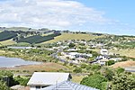
Challis is a settlement on the Otago Harbour coast of Otago Peninsula, within the city limits of the New Zealand city of Dunedin. Though officially regarded as a suburb, the isolated nature of Challis means that most locals regard it as a separate settlement within the city limits (as is also the case with many similar settlements on the Otago Peninsula). Challis is located close to the shore at the foot of steeply sloping hills and cliffsides 4 kilometres (2.5 mi) to the east of Dunedin city centre on the winding Portobello Road, which runs along the northern shore of the peninsula. Challis is connected by this road to the suburb of Vauxhall 1.8 kilometres (1.1 mi) to the west, and with Macandrew Bay, 2.6 kilometres (1.6 mi) to the northeast. The larger settlement of The Cove lies immediately to the west, between Challis and Vauxhall.

Excerpt from the Wikipedia article Challis, New Zealand (License: CC BY-SA 3.0, Authors, Images).

Challis, New Zealand
Portobello Road, Dunedin Macandrew Bay

Geographical coordinates (GPS) Address Nearby Places
placeShow on map

Wikipedia: Challis, New ZealandContinue reading on Wikipedia

Geographical coordinates (GPS)

Latitude Longitude
N -45.879722222222 ° E 170.56111111111 °
placeShow on map

Address

Portobello Road

Portobello Road
9014 Dunedin, Macandrew Bay
Otago, New Zealand
mapOpen on Google Maps

ChallisNZ
ChallisNZ
Share experience

Nearby Places

Shiel Hill

Shiel Hill is a residential suburb of the New Zealand city of Dunedin. It is located at the southeastern edge of the city's urban area, 3.2 kilometres (2.0 mi) southeast of the city's centre at the western end of the Otago Peninsula, close to the isthmus joining the peninsula to the mainland. As the name suggests, it is situated on the slopes of a hill at the start of the ridge which runs along the spine of the peninsula. The slopes rise to a series of crests generally known collectively as Highcliff, a name also often applied to the last suburban vestiges which remain as Dunedin's urban area becomes the rural land of the peninsula. More accurately, the name is that of a cliff which lies on the Pacific coast of the peninsula 4 kilometres (2.5 mi) east of Shiel Hill. The suburb is almost entirely residential, though there are some retail premises on the suburb's main road, Highcliff Road. These include a small nexus of shops at the southwestern edge of Shiel Hill, at the point where the suburb joins the neighbouring suburb of Andersons Bay. At this point, there is a road junction, with the western end of Highcliff Road meeting four other roads, notably Silverton Street (which leads down into Andersons Bay and is the main route from Shiel Hill to central Dunedin) and Tomahawk Road (which leads to Dunedin's Pacific coastal suburbs of Tahuna and Ocean Grove). Notable features of Shiel hill include Rotary Park, a small public reserve surrounding reservoirs which serve the Peninsula hill suburbs. This park is located above steep slopes which drop 166 metres (545 ft) to the waters of the Otago Harbour close to The Cove, half a kilometre to the north of the park. From Rotary Park, views can be obtained across and along the harbour to central Dunedin to the northwest, Signal Hill to the north, and Port Chalmers to the northeast.The suburb of Shiel Hill hit the news headlines in Dunedin in 1995 after one of Dunedin's most notorious crimes was committed in Every Street, close to the boundary of Shiel Hill and Andersons Bay. The case, in which five of the six members of the Bain family were slain led to one of New Zealand's most prominent causes célèbres after the remaining member of the family, David Bain was arrested for the murders despite evidence indicating that the slayings may well have been a murder-suicide by his father Robin. David Bain was found guilty and served 13 years of a life sentence before succeeding in having the case reopened. His retrial, in 2009, resulted in a verdict of not guilty.

Glenfalloch Gardens

Glenfalloch is a private garden and restaurant near Macandrew Bay on Otago Peninsula, New Zealand. The gardens are owned and run by the Otago Peninsula Trust.Glenfalloch was established in 1871 by George Gray Russell, who bought the land from pioneer settler James Macandrew. It covers 12.1 hectares (30 acres). Russell, a businessman who helped found the National Mortgage & Agency Co Ltd (now part of Fletcher Challenge), set out the gardens and lived at Glenfalloch until 1900. Phillip Barling purchased Glenfalloch in 1917, and the gardens were opened to the public by his son in 1956. The Otago Peninsula Trust purchased the property in the late 1960s.Glenfalloch's name is Gaelic, and means "hidden valley". The heart of the gardens is a woodland area with native trees dating back prior to the garden's establishment, including one matai estimated to be 1000 years old, as well as many exotic species planted in the late 19th century by the gardens' first owner. The small Russell Creek runs through the gardens down to an open lawn area around the restaurant and homestead. Many flower species are found in the gardens, with rhododendrons, azaleas, roses, magnolias, and fuchsias dominating. The Homestead is registered as a Category II historic place by Heritage New Zealand.Glenfalloch is regularly involved in and host of cultural events, including an annual spring festival of art and regular poetry readings. An arts residency aimed at potters and ceramicists is also run by the Otago Peninsula Trust, with the gardens' potters studio and cottage available to the recipient.

Ocean Grove, New Zealand

Ocean Grove, also known as Tomahawk, is a suburb in the southeast of the New Zealand city of Dunedin. A semi-rural residential suburb on the Pacific coast at the southwestern end of the Otago Peninsula, Ocean Grove is located 6.5 kilometres (4.0 mi) southeast of Dunedin city centre. The suburb is isolated from much of the city by the bluff of Lawyers Head, which rises immediately to the west of the suburb and the Andersons Bay Cemetery, and as such has the feel of a separate community. The suburb lies close to the banks of the Tomahawk Lagoon, a twin-lobed lagoon noted for its bird life. The inner lobe is a wildlife reserve. Tomahawk Lagoon is separated from the sea at low tide by Tomahawk Beach, which runs east from the Lagoon's mouth for about 1 kilometre (0.62 mi). A smaller beach, Smaills Beach, lies further to the east, beyond which is the outcrop of Maori Head, 2 kilometres (1.2 mi) from the lagoon's mouth. A rocky reef and the small Bird island lie close to the headland. The suburb was known as Tomahawk until the 1930s, The name "Tomahawk", documented in the Otago Witness from 1852, is unlikely to be a reference to the weapon. It is more likely an anglicized form of the Māori words toma haka, often interpreted as "dance by a gravesite". Toma means a place of bones, or shrine for bones; haka is here taken to mean the Māori dance of challenge, but may rather be the Southern Māori form of the word hanga, to build or create. The suburb became part of Dunedin City in 1968. The suburb has one main road, Tomahawk Road, which runs roughly parallel with the coast and links with the suburbs of Andersons Bay and Tainui in the west. In the east, it becomes the rural Centre Road, which climbs to the ridge at the centre of the Otago peninsula before joining with Highcliff Road, the ridge road which runs between Shiel Hill and Portobello. Ocean Grove's most notable structures are the remains of two World War II gun emplacements. These stand close to the Jack Fox Lookout, which is at the top of the promontory which separates Tomahawk Beach from Smaills Beach. A notable two-storey house, Glen Cairn, the original Smaill family homestead, is located at Smaills Beach. It is now used as the headquarters of the Tautuku Fishing Club. Between Tomahawk Beach and Tomahawk Road is Tomahawk Domain and recreation ground, which serves as a sports ground and is home to Grants Braes football club.

Waverley, Dunedin

Waverley is a suburb of the New Zealand city of Dunedin. It was named after Sir Walter Scott's novel Waverley, first novel in a series known as the Waverley Novels, among the most popular and widely read English-language novels of the 19th century. Waverley is located at the start of the Otago Peninsula, 2.4 kilometres (1.5 mi) southeast of the city centre, on a rise overlooking the Otago Harbour to the north. The suburb is connected to central Dunedin by several streets of which Larnach Road is the most prominent. This descends from the suburb to link with Marne Street on the eastern shore of the Andersons Bay Inlet. Marne Street connects with the suburbs of Andersons Bay and Musselburgh to the south, and in the north links with the causeway which carries Portobello Road from South Dunedin along the northern shore of the Otago Peninsula. Notable other roads linking Waverley and other suburbs include Doon Street, which winds down the steep slopes above the harbour to link Waverley with Vauxhall at Portobello Road, and McKerrow Street, which climbs from northeast Waverley to meet with Highcliff Road at the northern end of Shiel Hill. The suburb stands on land which was owned by Dunedin early settler The Reverend Thomas Burns, whose dairy farm, Grant Braes, was located here. The farm was named for Burns's wife, whose maiden name was Grant. The original farmhouse still stands, incongruously surrounded by modern housing, and the area of Waverley close to the northern end of Belford Street is still known by the slightly amended name of Grants Braes. Today, the name is best known as that of a local football team, Grants Braes AFC, whose home ground is located 2 km (1.2 mi) to the southeast at Ocean Grove.

Signal Hill (New Zealand)

Signal Hill (Maori: Te Pahuri o te Rangipohika) is a prominent landform in the city of Dunedin, New Zealand. It is located close to, and due north of, the head of the Otago Harbour and reaches an elevation of 393 m (1289 ft). The suburbs Ravensbourne, St. Leonards, and Opoho lie on its southern, eastern, and northwestern flanks, respectively. To the northwest is North East Valley, the thalweg of Lindsay Creek, a tributary of the Water of Leith. The southernmost spur of Signal Hill, Logan Point, has been extensively quarried for road gravel. State Highway 88 skirts the foot of the hill close to the edge of the Otago Harbour. A secondary summit of the hill (height 329 m) is capped by a monument to the New Zealand Centennial of 1940, a large structure including two large bronze figures representing "History" and "The Thread of Life" designed by F. W. Sturrock and F. W. Staub. Although commissioned for the centenary of the signing of the Treaty of Waitangi, the monument was not constructed until the 1950s, owing to the enforced strictures of World War II. A large stone from Edinburgh in Scotland is also incorporated in the monument, symbolising the ties between Dunedin and its sister city. The monument is surrounded by a scenic reserve 180 hectares in extent. This park was inaugurated as a much smaller park in 1926, and has gradually been extended to its current size. The reserve, located only five kilometres from central Dunedin, is a popular site for both locals and visitors, and affords an excellent panoramic view over the city. In October 2006, a series of bush fires caused extensive damage to the plantations of forest which cover the western slopes of the hill.