place

Waverley, Dunedin

Otago PeninsulaSuburbs of DunedinUse New Zealand English from January 2022

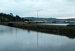
Waverley is a suburb of the New Zealand city of Dunedin. It was named after Sir Walter Scott's novel Waverley, first novel in a series known as the Waverley Novels, among the most popular and widely read English-language novels of the 19th century. Waverley is located at the start of the Otago Peninsula, 2.4 kilometres (1.5 mi) southeast of the city centre, on a rise overlooking the Otago Harbour to the north. The suburb is connected to central Dunedin by several streets of which Larnach Road is the most prominent. This descends from the suburb to link with Marne Street on the eastern shore of the Andersons Bay Inlet. Marne Street connects with the suburbs of Andersons Bay and Musselburgh to the south, and in the north links with the causeway which carries Portobello Road from South Dunedin along the northern shore of the Otago Peninsula. Notable other roads linking Waverley and other suburbs include Doon Street, which winds down the steep slopes above the harbour to link Waverley with Vauxhall at Portobello Road, and McKerrow Street, which climbs from northeast Waverley to meet with Highcliff Road at the northern end of Shiel Hill. The suburb stands on land which was owned by Dunedin early settler The Reverend Thomas Burns, whose dairy farm, Grant Braes, was located here. The farm was named for Burns's wife, whose maiden name was Grant. The original farmhouse still stands, incongruously surrounded by modern housing, and the area of Waverley close to the northern end of Belford Street is still known by the slightly amended name of Grants Braes. Today, the name is best known as that of a local football team, Grants Braes AFC, whose home ground is located 2 km (1.2 mi) to the southeast at Ocean Grove.

Excerpt from the Wikipedia article Waverley, Dunedin (License: CC BY-SA 3.0, Authors).

Waverley, Dunedin
Belford Street, Dunedin Waverley

Geographical coordinates (GPS) Address Nearby Places
placeShow on map

Wikipedia: Waverley, DunedinContinue reading on Wikipedia

Geographical coordinates (GPS)

Latitude Longitude
N -45.885 ° E 170.53388888889 °
placeShow on map

Address

Belford Street

Belford Street
9013 Dunedin, Waverley
Otago, New Zealand
mapOpen on Google Maps

Share experience

Nearby Places

Shiel Hill

Shiel Hill is a residential suburb of the New Zealand city of Dunedin. It is located at the southeastern edge of the city's urban area, 3.2 kilometres (2.0 mi) southeast of the city's centre at the western end of the Otago Peninsula, close to the isthmus joining the peninsula to the mainland. As the name suggests, it is situated on the slopes of a hill at the start of the ridge which runs along the spine of the peninsula. The slopes rise to a series of crests generally known collectively as Highcliff, a name also often applied to the last suburban vestiges which remain as Dunedin's urban area becomes the rural land of the peninsula. More accurately, the name is that of a cliff which lies on the Pacific coast of the peninsula 4 kilometres (2.5 mi) east of Shiel Hill. The suburb is almost entirely residential, though there are some retail premises on the suburb's main road, Highcliff Road. These include a small nexus of shops at the southwestern edge of Shiel Hill, at the point where the suburb joins the neighbouring suburb of Andersons Bay. At this point, there is a road junction, with the western end of Highcliff Road meeting four other roads, notably Silverton Street (which leads down into Andersons Bay and is the main route from Shiel Hill to central Dunedin) and Tomahawk Road (which leads to Dunedin's Pacific coastal suburbs of Tahuna and Ocean Grove). Notable features of Shiel hill include Rotary Park, a small public reserve surrounding reservoirs which serve the Peninsula hill suburbs. This park is located above steep slopes which drop 166 metres (545 ft) to the waters of the Otago Harbour close to The Cove, half a kilometre to the north of the park. From Rotary Park, views can be obtained across and along the harbour to central Dunedin to the northwest, Signal Hill to the north, and Port Chalmers to the northeast.The suburb of Shiel Hill hit the news headlines in Dunedin in 1995 after one of Dunedin's most notorious crimes was committed in Every Street, close to the boundary of Shiel Hill and Andersons Bay. The case, in which five of the six members of the Bain family were slain led to one of New Zealand's most prominent causes célèbres after the remaining member of the family, David Bain was arrested for the murders despite evidence indicating that the slayings may well have been a murder-suicide by his father Robin. David Bain was found guilty and served 13 years of a life sentence before succeeding in having the case reopened. His retrial, in 2009, resulted in a verdict of not guilty.

Andersons Bay Cemetery

Andersons Bay Cemetery is a major cemetery in the New Zealand city of Dunedin. It is located 4 kilometres (2.5 mi) to the southeast of the city centre, on a rocky outcrop which forms the inland part of Lawyers Head, a promontory which juts into the Pacific Ocean. The cemetery is bounded on the western and southern sides by Chisholm Park Golf Links, and to the east by steep slopes which descend to the Tomahawk Lagoon. Despite its name, the cemetery is located in the suburb of Tahuna, which lies immediately to the south of the suburb of Andersons Bay, and almost 1 kilometre (0.62 mi) from the former (now largely reclaimed) bay itself, at the head of the Otago Harbour. The cemetery is the largest in Dunedin, and as such one of the largest in the South Island. In existence by 1867, the cemetery was the city's main burial site from the early twentieth century until the 1980s, and also contains several older sets of remains which were re-interred here from other sites. Since the 1980s, the role of Dunedin's main cemetery has been split between several sites, with the Green Park Cemetery at Waldronville taking the majority of new burials. The crematorium, opened in 1927, is still in use. The Commonwealth War Graves Commission (CWGC) commemorates 2 World War II New Zealand servicemen cremated here.The cemetery originally went by the imposing name of the Eastern Necropolis, but this quickly fell out of favour to be replaced with its current, more prosaic, name. Andersons Bay Cemetery is noted for its large military memorial section, with many ex-servicemen having been buried here. Notable among them are Victoria Cross recipients Duncan Gordon Boyes and Horace Robert Martineau. The latter is one of 64 World War I Commonwealth service personnel buried here whose graves are registered and maintained by the CWGC, who are also responsible for 54 war graves from World War II.The cemetery is also notable for its section of restored gravestones of early Dunedin Chinese settlers. Other prominent people buried in the cemetery include architects Edmund Anscombe and Francis Petre.

Tainui, New Zealand
Tainui, New Zealand

Tahuna and Tainui are two small, somewhat vaguely defined suburbs of the New Zealand city of Dunedin. They lie to the south of Andersons Bay and Musselburgh, close to Dunedin's southern coastline (Ocean Beach). Both are often considered parts of either Musselburgh or Andersons Bay. Tainui lies to the north, in the area of residential housing which lies in the southeastern corner of "The Flat" (southern Dunedin's wide coastal plain) between Victoria and Tahuna Roads in the south and Musselburgh Rise in the north. Its eastern boundary is the start of a section of the Musselburgh Rise skirted by Tainui Road. Notable features of Tainui include Culling Park, a sports ground which is the home of Dunedin Technical football club. To the south of Tainui is Tahuna. This suburb stretches along Victoria and Tahuna Roads, and is largely dominated by several areas of open space which lie to the south between these roads and the ocean. These open spaces include two notable sports venues: Chisholm Park Golf Course and Tahuna Park. Chisholm Park is a championship-standard links course featuring one of New Zealand's finest holes, Lawyers Head. This hole dog-legs around craggy cliffs with the ocean pounding at their feet, and as such is both visually impressive and technically difficult. The course was founded in 1937 and extended from nine to 18 holes in 1941. Tahuna Park houses Dunedin's A&P showgrounds, and was the city's first rugby union and rugby league test venue. The grounds were inaugurated in a 20-acre (8.1 ha) here in 1883, and the park's only union test match was played in 1905, with the All Blacks beating Australia 14-3. The park hosted the 1924 Great Britain side when they defeated the New Zealand rugby league side 31-18 in front of 16,000 fans.The third notable open space close to the coast is the Andersons Bay Cemetery, Dunedin's biggest cemetery. This is located at the southeastern end of Tahuna, and is bounded to the west and south by Chisholm Park Golf Links. The cemetery occupies a prominent rise that juts into the sea as Lawyers Head. The cemetery was opened in 1867, but is now largely full. A crematorium, inaugurated in 1962, occupies a prominent spot close to the cliffs. Beyond the cemetery, Tahuna Road reaches a Y-junction with Tomahawk Road, which descends to the southeast to follow the coast to the suburb of Ocean Grove and rises to the north to meet with Silverton Road, Andersons Bay at that suburb's boundary with Shiel Hill. This area of Tahuna was formerly known as Ocean View, a name which is still occasionally encountered, though this name has fallen out of use due to confusion with the settlement of the same name which lies 15 kilometres (9.3 mi) to the southwest near Brighton.