place

Ragged Island (Massachusetts)
Boston Harbor islandsBoston geography stubsCoastal islands of MassachusettsHingham, MassachusettsIslands of Plymouth County, Massachusetts
Uninhabited islands of Massachusetts
Ragged Island Hingham Ma

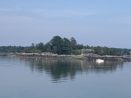
Ragged Island is an island in the Hingham Bay area of the Boston Harbor Islands National Recreation Area, in the U.S. state of Massachusetts. The island has a permanent size of 4 acres (16,000 m2), and it is composed of Roxbury puddingstone (pebbles embedded in finer-grained cement) which rises to a height of 30 feet (9.1 m) above sea level. Broken ledges surround most of the island with small gravel beaches on the southeast and northwest sides; there are also small tidal mudflats.The island was first occupied by John Langlee in the late seventeenth century. In the late nineteenth century, it was developed as part of a summer resort, and it has subsequently been the site of a restaurant and rustic observation shelters. Today, it is uninhabited and has an interesting mix of cultivated and naturalized plants, including lily-of-the-valley, daylily, silver maple, red maple, Norway maple, cedar, Norway spruce, linden, greenbrier and poison ivy. The island is managed by the town of Hingham and access is by private boat only.

Excerpt from the Wikipedia article Ragged Island (Massachusetts) (License: CC BY-SA 3.0, Authors, Images).

Ragged Island (Massachusetts)
Otis Street,

Geographical coordinates (GPS) Address Nearby Places
placeShow on map

Wikipedia: Ragged Island (Massachusetts)Continue reading on Wikipedia

Geographical coordinates (GPS)

Latitude Longitude
N 42.257205555556 ° E -70.890438888889 °
placeShow on map

Address

Otis Street 169
02043
Massachusetts, United States
mapOpen on Google Maps

Ragged Island Hingham Ma
Share experience

Nearby Places

Slate Island
Slate Island

Slate Island is an uninhabited island of about 12.7 acres (5.1 ha) (at high tide) in Hingham Bay, an arm of Boston Harbor. It is part of Boston Harbor Islands National and State Park and is just east of Grape Island. The island mostly consists of slate outcrops partly covered with glacial till, and the shore is mostly rock. The highest elevation is 32 feet (9.8 m). The island was visited seasonally by Native Americans. In colonial times slate was quarried from the islands (the remnants of the quarry are still visible), mostly for house foundations. William Torey was given a grant for the island in 1650, with a stipulation that anyone was free to extract slate. Slate mining continued to a small degree into the 20th century and contributed to soil erosion on the rocky island. Later owners included Joseph Andrews, Samuel Lovell, Thomas Jones, and Caleb Loring. In the 17th century the island became part of the town of Hull (it is now in Weymouth). Around 1840 a hermit (his name lost to history) lived in a hut near the southern cove. (Moses Forster Sweetser opined that "his lonely hut must have made Thoreau's hermitage at Walden seem like Scollay Square after a theatre performance.") In the 1890s owner Edwin Clapp gave the island to the Clapp Memorial Association, which briefly hosted a summer camp there. Slate Island was privately owned until the 1970s when it became public property and part of the Boston Harbor Islands National and State Park. There are no trails, docks, or any other facilities on the island, which is overrun with vegetation including an abundance of poison ivy. The island is not serviced by the park ferry.