Rettbergsaue

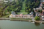
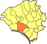
The Rettbergsaue (translated from German as “Rettberg Island”) is a natural island in the Rhine River at Wiesbaden, Germany. It is situated between the main channel of the Rhine to the north and a smaller channel, the Wachsbleicharm, in the south. The Wachsbleicharm forms the border between the federal states of Hesse (of which Wiesbaden is the capital) and Rhineland-Palatinate. The island is about 3,100 meters (10,200 ft) long and up to 400 m (1,300 ft) wide. Covering about 68 hectares (170 acres), it is one of the largest islands on the Rhine in which the river flows unhindered on both sides. The island is for the most part covered with trees and has a rich bird and plant life. Approximately 90% of the island is protected, with the remainder used for recreational and agricultural purposes.Bundesautobahn 643 crosses the Rhine via the Rettbergsaue on the Schierstein Bridge. Although there is a sidewalk on both sides of the road on the bridge, only the sidewalk on the east side has stairs to access the island. The majority of the island, lying opposite Biebrich Castle, is within the borough of Wiesbaden-Biebrich. The part west of the Schierstein Bridge is part of Wiesbaden-Schierstein.
Excerpt from the Wikipedia article Rettbergsaue (License: CC BY-SA 3.0, Authors, Images).Rettbergsaue
Uferstraße, Wiesbaden Biebrich
Geographical coordinates (GPS) Address Nearby Places Show on map
Geographical coordinates (GPS)
| Latitude | Longitude |
|---|---|
| N 50.034444444444 ° | E 8.2211111111111 ° |
Address
Strandbad Biebrich
Uferstraße
65203 Wiesbaden, Biebrich
Hesse, Germany
Open on Google Maps


