place

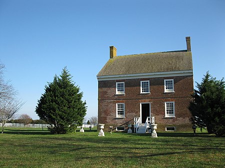
Henry's Grove

Berlin, MarylandHistoric American Buildings Survey in MarylandHouses completed in 1792Houses in Worcester County, MarylandHouses on the National Register of Historic Places in Maryland
National Register of Historic Places in Worcester County, MarylandSalisbury metropolitan area, Maryland Registered Historic Place stubs
Henry's Grove, angled (21603599346)

Henry's Grove is a historic home located at Berlin, Worcester County, Maryland, United States. It was built in 1792, and is a 2+1⁄2-story gable-roofed brick house with all walls laid in Flemish bond. The house retains virtually all of its original interior detailing. Also on the property are a 20th-century frame tenant house and four frame outbuildings. It was built for a planter, John Fassitt, whose initials and the date 1792 are inscribed on a plaque in a gable end.Henry's Grove was listed on the National Register of Historic Places in 1984.

Excerpt from the Wikipedia article Henry's Grove (License: CC BY-SA 3.0, Authors, Images).

Geographical coordinates (GPS)

Latitude Longitude
N 38.269444444444 ° E -75.150277777778 °
placeShow on map

Address

Worcester County


Maryland, United States
mapOpen on Google Maps

Henry's Grove, angled (21603599346)
Share experience

Nearby Places

Sinepuxent Bay
Sinepuxent Bay

Sinepuxent Bay is an inland waterway which connects Chincoteague Bay to Isle of Wight Bay, and is connected to the Atlantic Ocean via the Ocean City Inlet. It separates Sinepuxent Neck, in Worcester County, Maryland from Assateague Island, and West Ocean City, Maryland from downtown Ocean City. Islands in the Sinepuxent Bay include Horn Island and Skimmer Island. It is crossed by the Harry W. Kelley Memorial Bridge on U.S. Route 50 and the Verrazano Bridge on Maryland Route 611 (not to be confused with the Verrazano-Narrows Bridge in New York City; both were named for Giovanni da Verrazzano, who explored the coastline in 1524). The bay is the location of the islands that compose the Sinepuxent Bay Wildlife Management Area. Historically the area was referred to by various names including Sinepuxent, Sene Puxon, Synepuxent, Cinnepuxon, et al. Sinepuxent Inlet, a navigable waterway through the barrier island during the colonial era, was located just south of the Assateague Island National Seashore day-use area. In September 1698 French pirate Canoot seized a Philadelphia-based sloop "as he was coming out of Cinnepuxon Inlet." The Inlet was closed in a hurricane in 1818, and was filled in by sand in 1860. Sinepuxent was a once-thriving community on the mainland about a half mile north of the Verrazano Bridge, also destroyed in the same hurricane. The current inlet, known as Ocean City Inlet, was cut by the great 1933 Chesapeake–Potomac hurricane, also known as Hurricane Six of 1933. The new inlet was stabilized by rock jetties constructed by the United States Army Corps of Engineers, with work commencing in October 1933. Because of the changes that the creation of the Ocean City Inlet made to tidal flows in the bays, the United States Army Corps of Engineers now internally defines the Isle of Wight Bay as extending south to the inlet, and Sinepuxent Bay extending south from the inlet to Chincoteague Bay, despite historical naming conventions.

Germantown, Worcester County, Maryland

Germantown is an unincorporated community in Worcester County, Maryland, United States. It is located at 38°18′30″N 75°12′35″W at the intersection of Germantown and Bethel roads, southeast of Berlin. This historically black community is the location of several AME churches, including Tyree AME, begun by relatives of Methodist minister the Rev. Dr. Charles Tindley, the man whose hymn "I Shall Overcome" became the germ for the very memorable civil rights anthem, "We Shall Overcome." Germantown Road crosses Route 113 to become South Main St of Berlin, MD ("America's Coolest Small Town" 2014). At one time the community was known as Germantown, possibly in reference to the name Berlin, whose derivation is questioned, some saying it's a morphology of Burley Inn. Historically, Berlin and Germantown are nearly totally segregated. While some whites and latinos now live on the east side of 113, hardly any black families own property in Berlin on the west side of 113. Parts of Germantown are within Berlin town limits, including Tyree church. Like other low elevation parts of Worcester County, Germantown contributes to the subtle wetland ecosystem feeding into Newport Bay. At one time, long carefully maintained ditches were essential to prevent flooding and allow for agriculture. The soil there, like much of Worcester county and the Maryland Eastern Shore in general, is often USDA prime agricultural soil, a deep black humus enriched loam topsoil with a clayey loam base. Hardly any stones are encountered. However, the soil can be variable, and wooded areas can be deep with centuries of leaf mold. In general, soft ground, especially during spring, after snow melt and rains, is a perennial problem. Wells and septic systems are used, either new expensive and finicky sand mounds or like most something which was grandfathered in. The forest is dense, and similar to that of surrounding areas, with abundant sweet gum pioneers eventually giving way to large, often massive loblolly pines. Loss of property by tax lien auctions held annually by Worcester county for properties 2 years in arrears is a persistent threat to black property ownership, though many families can trace family homes going back to the Reconstruction. Tax liens are often purchased by local or in state investors, out of state LLCs domiciled in Delaware, and on occasion large foreign conglomerates looking for anything approximate to Atlantic coastal areas. Much of the properties are rentals, with absentee landlords using local real estate agents as property managers. These are notably poorly maintained, but generally the owner occupied single family houses are cared for with pride, even the most humble ones.