Whakarewarewa

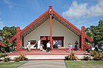
Whakarewarewa (reduced version of Te Whakarewarewatanga O Te Ope Taua A Wahiao, meaning The gathering place for the war parties of Wahiao, often abbreviated to Whaka by locals) is a Rotorua semi-rural geothermal area in the Taupo Volcanic Zone of New Zealand. This was the site of the Māori fortress of Te Puia, first occupied around 1325, and known as an impenetrable stronghold never taken in battle. Māori have lived here ever since, taking full advantage of the geothermal activity in the valley for heating and cooking. Whakarewarewa has some 500 pools, most of which are alkaline chloride hot springs, and at least 65 geyser vents, each with their own name. Seven geysers are currently active. Pohutu Geyser, meaning big splash or explosion, erupts approximately hourly to heights of up to 30 m (98 ft).Many of the thermal features at Whakarewarewa have been adversely affected by Rotorua residents taking advantage of the underlying geothermal fluids of the city by drawing shallow wells (20–200 m [66–656 ft] deep) to extract hot water for both domestic and commercial heating. A bore closure programme in 1987–1988 resulted in 106 wells within 1.5 km (0.93 mi) of Pohutu Geyser being cemented shut, with another 120 wells outside the radius being shut due to a punitive royalty charging regime. There has subsequently been a pronounced recovery in the geysers and hot springs at Whakarewarewa.The area features Te Pākira Marae and Wahiao meeting house, a meeting place of the Tūhourangi hapū of Ngāti Puta, Ngāti Uruhina, Ngāti Wāhiao, Tūhourangi and Ngāti Taoi.
Excerpt from the Wikipedia article Whakarewarewa (License: CC BY-SA 3.0, Authors, Images).Whakarewarewa
Wahiao Drive, Rotorua Whakarewarewa
Geographical coordinates (GPS) Address Nearby Places Show on map
 Continue reading on Wikipedia
 Geographical coordinates (GPS)
| Latitude | Longitude |
|---|---|
| N -38.162222222222 ° | E 176.25638888889 ° |
Address
Wahiao Drive 25
3010 Rotorua, Whakarewarewa
Bay of Plenty, New Zealand
Open on Google Maps