place

Natick High School

Bay State ConferenceHigh schools in Middlesex County, MassachusettsNatick, MassachusettsPublic high schools in Massachusetts

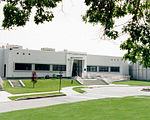
Natick High School is an urban/suburban public high school serving students in grades 9 to 12 in Natick, Massachusetts, United States. The school is located on the banks of Dug Pond. Its enrollment was 1,603 students during the 2015–2016 school year. The original building was built in 1953 at approximately 189,000 sq ft (17,600 m2). and opened in 1954. The building was expanded in 1965 (additional 94,000 sq ft.). Additional renovations took place in 1985. In 2010, the town voted to replace the Natick High School building. The new facility was constructed on the fields immediately to the south of the former building. Demolition on the former building began on June 25, 2012. The new building design is based on a model approved by the state of Massachusetts. This was necessary in order to maximize state reimbursement for design and construction; it cost $78 million. The new high school opened to students on August 29, 2012.

Excerpt from the Wikipedia article Natick High School (License: CC BY-SA 3.0, Authors).

Natick High School
Rocky Hill Road,

Geographical coordinates (GPS) Address External links Nearby Places
placeShow on map

Wikipedia: Natick High SchoolContinue reading on Wikipedia

Geographical coordinates (GPS)

Latitude Longitude
N 42.274697222222 ° E -71.361766666667 °
placeShow on map

Address

Natick High School

Rocky Hill Road
01760
Massachusetts, United States
mapOpen on Google Maps

linkWikiData (Q6970015)
linkOpenStreetMap (310753342)

Share experience

Nearby Places

Edward's Plain–Dowse's Corner Historic District

The Edward's Plain–Dowse's Corner Historic District is a predominantly residential historic district encompassing an area where light industrial activity took place from the late 18th century to the early 20th century. It extends along North Main Street between Eliot and Everett Streets in Sherborn, Massachusetts, and was listed on the National Register of Historic Places in 1986.Sherborn was a sparsely populated town until the time of the American Revolutionary War. The Edward's Plain area, in the south of the district, was probably named for Edward West, who was appointed the local schoolmaster in 1694. Dowse's Corner, at the north end of the district, is named for Ebenezer Dowse, who settled in Sherborn after fleeing Charlestown before the 1775 Battle of Bunker Hill. Dowse became a significant figure in the local industrial pursuits, establishing an early tannery in the buggy lowlands behind his house. Members of the Dowse family built a number of the houses in the area, predominantly Greek Revival houses built c. 1840-60. Dowse's efforts were the beginning of a cottage industry in shoe-making which persisted into the early 20th century. Most of the buildings associated with this and other small industry have either been lost to fire, been converted to residential uses, or moved out of the area.One of the more notable industrial buildings to survive is the only stone building in the district. Nathaniel Partridge in 1796 built a stone structure to house a factory for manufacturing edged tools, which still stands at 53-55 North Main Street, adjacent to the Federal-style Harvey Partridge House at 51 North Main. The Plain School (built 1834) at 60 North Street, is the only building in the district that is not now residential in use.