Pavlovo, Sofia
Bulgaria geography stubsNeighbourhoods of Sofia
_E1.jpg)
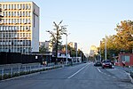
Pavlovo (Bulgarian: Павлово) is a southern neighbourhood of Sofia, the capital of Bulgaria. Part of the Vitosha municipality, it borders Buxton Neighbourhood to the northeast, Tsar Boris III Boulevard to the northwest, the Sofia ringroad (in this section known as the Nikola Petkov Boulevard) to the south and the Buxton Boulevard to the east. Pavlovo features mostly low - to mid-rise residential architecture, with houses and small blocks of flats dominating the skyline. The 5th Primary School and the 157th High School César Vallejo serve the neighbourhood.
Excerpt from the Wikipedia article Pavlovo, Sofia (License: CC BY-SA 3.0, Authors, Images).Pavlovo, Sofia
Kota 1050, Sofia zh.k. Buxton
Geographical coordinates (GPS) Address Nearby Places Show on map
 Continue reading on Wikipedia
 Geographical coordinates (GPS)
| Latitude | Longitude |
|---|---|
| N 42.662777777778 ° | E 23.268333333333 ° |
Address
Kota 1050 22
1618 Sofia, zh.k. Buxton
Bulgaria
Open on Google Maps