place

Lake Micmac

AC with 0 elementsGeographic coordinate listsHalifax County, Nova Scotia geography stubsLakes of Nova ScotiaLandforms of Halifax, Nova Scotia
Landforms of Halifax County, Nova ScotiaLists of coordinates
Red Bridge Pond and Lake Micmac

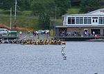
Lake Micmac is a freshwater lake located in the Halifax Regional Municipality in Nova Scotia, Canada. Located entirely within the community of Dartmouth, Lake Micmac is also known as 'Second Lake' for its position in the Shubenacadie Canal system. The lake is bordered on three sides by roads: Waverly Road on its eastern shore, Highway 118 on its western shore, and Highway 111 on its southern shore; the bridge carrying this latter road also separates Lake Micmac from Lake Banook. The north shore of Lake Micmac is occupied by Shubie Park, a large urban park. There is also private beach frontage known informally as 'Mossman's Beach' on the northeastern end of the lake. Lake Micmac is a popular location for water sports and boating; the lake features a boat launch at Red Bridge Pond. Lake Micmac is named after the Mi'kmaq Nation who used the Shubenacadie portage route as a transportation corridor before the arrival of European settlers. Several pre-colonial archaeological sites have been found in the area of Shubie Park; many of the artifacts that were recovered are on display at the park's Fairbanks Centre.

Excerpt from the Wikipedia article Lake Micmac (License: CC BY-SA 3.0, Authors, Images).

Lake Micmac
Garshan Road, Dartmouth Port Wallace

Geographical coordinates (GPS) Address Nearby Places
placeShow on map

Wikipedia: Lake MicmacContinue reading on Wikipedia

Geographical coordinates (GPS)

Latitude Longitude
N 44.693166666667 ° E -63.553361111111 °
placeShow on map

Address

Garshan Road 24G
B2X 2H9 Dartmouth, Port Wallace
Nova Scotia, Canada
mapOpen on Google Maps

Red Bridge Pond and Lake Micmac
Share experience

Nearby Places

Shubie Park
Shubie Park

Shubie Park is a 16-hectare (40-acre) urban park in Dartmouth, Nova Scotia maintained by the Halifax Regional Municipality. Heavily forested, Shubie Park is roughly linear in shape as it is bounded on the north and west by Highway 118 expressway and on the south and east by Lake Micmac and the southern edge of Lake Charles. A portion of the abandoned Shubenacadie Canal passes through the park, from which the park takes its name. The main soil is a well to excessively drained stony sandy loam podzol of the Halifax Series.The land comprising Shubie Park was part of a larger estate called "Countryview" that had been established in 1722 as the King's wood lot, providing masts for the Royal Navy. In 1783, the Countryview estate became the first royal land grant in Dartmouth, issued by King George III to naval mast maker Samuel Greenwood. Since then, the land has exchanged hands several times, and in recent decades became home to industry including a rock quarry, asphalt plant and construction and demolition dump. At the time that Highway 118 was extended through the area on the northwest side of Lake Micmac during the 1960s-1970s, the remaining undeveloped land of the Countryview Estate bordering the greenbelt between the highway and lake was set aside as a municipal park for the City of Dartmouth. The municipality developed the park primarily as a green space, although an area bordering Lake Charles was established with a beach, day use picnic area and campground - all operated since a 1996 municipal amalgamation by the Halifax Regional Municipality. Shubie Park contains trails and an interpretive area called the Fairbanks Centre next to the canal at the location of a series of locks between Lake Micmac and Lake Charles. The Fairbanks Centre features a scale model of canal lock mechanisms and various displays. The wooded trails of the Shubie Canal Park follow a remaining section of the canal and include part of the Trans-Canada Trail.