place

Nova Scotia Route 318

Infobox road instances in Nova ScotiaInfobox road maps tracking categoryNova Scotia provincial highwaysNova Scotia road stubsRoads in Halifax, Nova Scotia

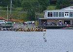
Route 318 is a collector road in the Canadian province of Nova Scotia. It is located in the Halifax Regional Municipality and connects Dartmouth at Exit 6 of Highway 111 with Waverley at Trunk 2. It is also called "Waverley Road" and "Braemar Drive." The road follows the north shore of Lake Micmac, Lake Charles, Nova Scotia, and Lake William, which comprise part of the historic Shubenacadie Canal route.

Excerpt from the Wikipedia article Nova Scotia Route 318 (License: CC BY-SA 3.0, Authors).

Nova Scotia Route 318
Waverley Road, Dartmouth Port Wallace

Geographical coordinates (GPS) Address Nearby Places
placeShow on map

Wikipedia: Nova Scotia Route 318Continue reading on Wikipedia

Geographical coordinates (GPS)

Latitude Longitude
N 44.693305555556 ° E -63.546527777778 °
placeShow on map

Address

Waverley Road 201
B2X 2C3 Dartmouth, Port Wallace
Nova Scotia, Canada
mapOpen on Google Maps

Share experience

Nearby Places

Shubie Park
Shubie Park

Shubie Park is a 16-hectare (40-acre) urban park in Dartmouth, Nova Scotia maintained by the Halifax Regional Municipality. Heavily forested, Shubie Park is roughly linear in shape as it is bounded on the north and west by Highway 118 expressway and on the south and east by Lake Micmac and the southern edge of Lake Charles. A portion of the abandoned Shubenacadie Canal passes through the park, from which the park takes its name. The main soil is a well to excessively drained stony sandy loam podzol of the Halifax Series.The land comprising Shubie Park was part of a larger estate called "Countryview" that had been established in 1722 as the King's wood lot, providing masts for the Royal Navy. In 1783, the Countryview estate became the first royal land grant in Dartmouth, issued by King George III to naval mast maker Samuel Greenwood. Since then, the land has exchanged hands several times, and in recent decades became home to industry including a rock quarry, asphalt plant and construction and demolition dump. At the time that Highway 118 was extended through the area on the northwest side of Lake Micmac during the 1960s-1970s, the remaining undeveloped land of the Countryview Estate bordering the greenbelt between the highway and lake was set aside as a municipal park for the City of Dartmouth. The municipality developed the park primarily as a green space, although an area bordering Lake Charles was established with a beach, day use picnic area and campground - all operated since a 1996 municipal amalgamation by the Halifax Regional Municipality. Shubie Park contains trails and an interpretive area called the Fairbanks Centre next to the canal at the location of a series of locks between Lake Micmac and Lake Charles. The Fairbanks Centre features a scale model of canal lock mechanisms and various displays. The wooded trails of the Shubie Canal Park follow a remaining section of the canal and include part of the Trans-Canada Trail.