Pont d'Aël

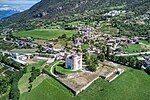
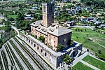
The Pont d'Aël (French pronunciation: [pɔ̃ dɛl]) is a Roman aqueduct located in a village of the same name in the comune of Aymavilles in Aosta Valley, northern Italy. It was built in the year 3BC for irrigation purposes and supplying water for the newly founded colony of Augusta Praetoria, which is now known as Aosta. The water was directed through a neighbouring valley 66 m above the floor of the Aosta valley, through a sophisticated system. The aqueduct is 6 km long in total. In addition to its unusual position, the construction, which was originally thought to be a three-story structure, shows more unique features such as a control corridor below the water line, as well as explicit private funding. Today, the water channel of the aqueduct serves as a public walking trail. Besides the Pont d'Aël, two other Roman bridges in the Aosta valley are still intact: the Pont-Saint-Martin in the town of the same name and the Pont de Pierre in Aosta.
Excerpt from the Wikipedia article Pont d'Aël (License: CC BY-SA 3.0, Authors, Images).Pont d'Aël
Pont D'Aël,
Geographical coordinates (GPS) Address Phone number Website External links Nearby Places Show on map
 Continue reading on Wikipedia
 Geographical coordinates (GPS)
| Latitude | Longitude |
|---|---|
| N 45.676667 ° | E 7.222309 ° |
Address
Pont D'Aël
Pont D'Aël
11010
Aosta Valley, Italy
Open on Google Maps
Phone number
Website
lovevda.it
External links