place

Tse-whit-zen

Archaeological sites in Washington (state)Buildings and structures in Clallam County, WashingtonKlallamNative American history of Washington (state)Pages with Salishan languages IPA
Tse whit zen NRHP 14000848 Clallam County, WA

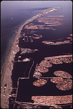
Tse-whit-zen (č̕ixʷícən [t͡ʃʼiˈxʷit͡sən] in the Klallam language, meaning "inner harbor") is a 1,700- to 2,700-year-old village of the Lower Elwha Klallam Tribe located along the Port Angeles, Washington waterfront. It is located at the base of Ediz Hook on the Olympic Peninsula. During construction in August 2003 of a graving dock associated with replacement of the Hood Canal Bridge, the village's cemetery and other prehistoric remains were discovered. The construction project was abandoned at this site because of the importance of the find, as the village was intact. It is the largest pre-European contact village site excavated in Washington State.Archaeological excavation has revealed more than 10,000 artifacts and more than 335 intact skeletons. The Washington State Department of Transportation decided to halt all construction efforts related to the graving dock on December 21, 2004. Since then it has worked to ensure the preservation of remains and artifacts already uncovered by the construction. As a result of a legal settlement with Washington State, the tribe received the land of the village site, as well as $2.5 million to build a cultural center or museum at the site. The tribe intended to begin construction around 2012.

Excerpt from the Wikipedia article Tse-whit-zen (License: CC BY-SA 3.0, Authors, Images).

Tse-whit-zen
Olympic Discovery Trail,

Geographical coordinates (GPS) Address Nearby Places
placeShow on map

Wikipedia: Tse-whit-zenContinue reading on Wikipedia

Geographical coordinates (GPS)

Latitude Longitude
N 48.1302 ° E -123.4618 °
placeShow on map

Address

Olympic Discovery Trail

Washington, United States
mapOpen on Google Maps

Tse whit zen NRHP 14000848 Clallam County, WA
Share experience

Nearby Places

Ediz Hook
Ediz Hook

Ediz Hook is a 3-mile-long (4.8 km) sand spit that extends from northern shore of the Olympic Peninsula at Port Angeles in northcentral Clallam County, Washington, USA, northeasterly into the Strait of Juan de Fuca, located about 15-mile (24 km) west of the larger Dungeness Spit. It is relatively narrow at points, but broader toward the base and the northeast tip. Much of the spit is accessible by car on the Ediz Hook Road (1.5 to 2 miles), which passes several turnouts and picnic areas, with broad views of Port Angeles and the Olympic Mountains, notably the peaks of Mount Angeles and Klahhane Ridge. To the north marine traffic can be observed, and orca pods, harbor seals and other marine life can be spotted. Several long stretches of public beach facilitate beachcombing and birdwatching. The end of the spit is used by the Coast Guard and not accessible to visitors. "The Hook" was created by wind and tidal action along the southern edge of the Strait, that carried sediment from the delta of the Elwha River eastward. The presence of the sand spit creates a natural harbor to the south, with the spit sheltering the area off Port Angeles from the large ocean-sourced swells that roll eastward down the Strait. The calm waters of the harbor and sandy beaches attracted people to the area long before the appearance of European explorers and settlers. Recently uncovered archeological evidence indicates that a community, known today as Tse-whit-zen, was occupied for generations by the Klallam Native American people.After white settlement, the Ediz Hook Light was established to guide ships safely by the spit in low-visibility conditions. Currently, the end of the spit serves as home for the Coast Guard Air Station Port Angeles. It is also the base of operations for the Puget Sound Pilots. For the past few decades, notable erosion of Ediz Hook has occurred. This is believed to be caused by the presence of the Elwha River dams, which have reduced the amount of sediment carried by the river. The Elwha Ecosystem Restoration project has completed a program of dam removal that has restored the original flow patterns of the Elwha river and is expected to diminish this loss. Several projects have added large boulders to the northwest side of the spit to slow its erosion and protect the Port Angeles Harbor.

Olympic National Park Headquarters Historic District

The Olympic National Park Headquarters Historic District overlooks Port Angeles, Washington from Peabody Heights, consisting of 6 contributing buildings built in 1940–44, 8 contributing structures and 17 non-contributing properties that act as the administrative headquarters for Olympic National Park. The contributing structures were built using locally obtained native materials in a late interpretation of the National Park Service Rustic style. Native landscaping enhances the site. Much of the work was carried out by Public Works Administration and Civilian Conservation Corps workers.The most significant building is the Administration Building (48°06′03″N 123°25′58″W), a two-story masonry and wood-frame structure with a long, horizontal design, emphasized by linear banding in the shingle cladding of the second story. The Custodian's Residence or Superintendent's Residence (48°06′03″N 123°25′53″W) housed the park superintendent until the 1980s when it was converted to offices. The irregularly shaped two-story building is similar in style and materials to the headquarters.A somewhat separated area comprises several maintenance buildings. The Gas and Oil House building (48°05′59″N 123°25′53″W) uses coursed stone and heavy timber, with a porte-cochere extending from the front to shelter gas pumps. The Transformer Vault and Pump House (48°05′59″N 123°25′59″W) is similar in character. The Equipment Shed/Carpenter Shop (48°05′58″N 123°25′55″W) is a stone and frame building in a saltbox shape with projecting bracketed eaves that anticipate the Mission 66 style structures on the 1950s and 1960s. The Equipment and Supply Building (48°05′57″N 123°25′54″W), measuring 199 feet (61 m) by 32 feet (9.8 m) is a masonry and frame building, with a large frame extension that burned in 1965. This section was replaced with a historically faithful copy in 1970.The Headquarters District is close to the park, but outside its primary boundaries. It was the first park headquarters to be situated outside its park. The district was placed on the National Register of Historic Places in 2007.