place

Clallam County, Washington

1854 establishments in Washington TerritoryClallam County, WashingtonPages with non-numeric formatnum argumentsPopulated places established in 1854Use mdy dates from December 2021
Washington (state) countiesWashington placenames of Native American originWestern Washington
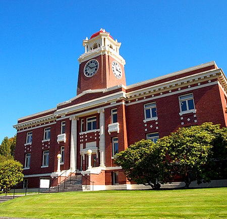
Clallam County Courthouse 09 11 13 Wiki

Clallam County is a county in the U.S. state of Washington. As of the 2020 census, the population was 77,155, with an estimated population of 77,805 in 2022. The county seat and largest city is Port Angeles; the county as a whole comprises the Port Angeles, WA Micropolitan Statistical Area. The name is a Klallam word for "the strong people". The county was formed on April 26, 1854. Located on the Olympic Peninsula, it is south from the Strait of Juan de Fuca, which forms the Canada–US border, as British Columbia's Vancouver Island is across the strait.

Excerpt from the Wikipedia article Clallam County, Washington (License: CC BY-SA 3.0, Authors, Images).

Clallam County, Washington
West 9th Street,

Geographical coordinates (GPS) Address Nearby Places
placeShow on map

Wikipedia: Clallam County, WashingtonContinue reading on Wikipedia

Geographical coordinates (GPS)

Latitude Longitude
N 48.1125 ° E -123.44083333333 °
placeShow on map

Address

West 9th Street 155
98362
Washington, United States
mapOpen on Google Maps

Clallam County Courthouse 09 11 13 Wiki
Share experience

Nearby Places

Olympic National Park Headquarters Historic District

The Olympic National Park Headquarters Historic District overlooks Port Angeles, Washington from Peabody Heights, consisting of 6 contributing buildings built in 1940–44, 8 contributing structures and 17 non-contributing properties that act as the administrative headquarters for Olympic National Park. The contributing structures were built using locally obtained native materials in a late interpretation of the National Park Service Rustic style. Native landscaping enhances the site. Much of the work was carried out by Public Works Administration and Civilian Conservation Corps workers.The most significant building is the Administration Building (48°06′03″N 123°25′58″W), a two-story masonry and wood-frame structure with a long, horizontal design, emphasized by linear banding in the shingle cladding of the second story. The Custodian's Residence or Superintendent's Residence (48°06′03″N 123°25′53″W) housed the park superintendent until the 1980s when it was converted to offices. The irregularly shaped two-story building is similar in style and materials to the headquarters.A somewhat separated area comprises several maintenance buildings. The Gas and Oil House building (48°05′59″N 123°25′53″W) uses coursed stone and heavy timber, with a porte-cochere extending from the front to shelter gas pumps. The Transformer Vault and Pump House (48°05′59″N 123°25′59″W) is similar in character. The Equipment Shed/Carpenter Shop (48°05′58″N 123°25′55″W) is a stone and frame building in a saltbox shape with projecting bracketed eaves that anticipate the Mission 66 style structures on the 1950s and 1960s. The Equipment and Supply Building (48°05′57″N 123°25′54″W), measuring 199 feet (61 m) by 32 feet (9.8 m) is a masonry and frame building, with a large frame extension that burned in 1965. This section was replaced with a historically faithful copy in 1970.The Headquarters District is close to the park, but outside its primary boundaries. It was the first park headquarters to be situated outside its park. The district was placed on the National Register of Historic Places in 2007.