Killamarsh
North East Derbyshire DistrictOpenDomesdayUse British English from June 2021Villages in Derbyshire

Killamarsh is a village and civil parish in North East Derbyshire, England, bordering Rotherham to the north and Sheffield to the north-west. Killamarsh is surrounded by, in a clockwise direction from the north, Rother Valley Country Park, the village of Wales, South Yorkshire, Kiveton, Woodall, Harthill, Barlborough, Spinkhill, Renishaw, Eckington, and the (former Derbyshire) Sheffield suburbs of Oxclose, Halfway and Holbrook. The name 'Killamarsh' is first attested in the Domesday Book of 1086, where it appears as Chinewoldemaresc. It appears as Kinewaldesmers in the Charter Roll for 1249. The name means 'Cynewald's marsh'.
Excerpt from the Wikipedia article Killamarsh (License: CC BY-SA 3.0, Authors, Images).Killamarsh
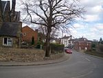
Ashley Lane, North East Derbyshire
Geographical coordinates (GPS) Address Nearby Places Show on map
Geographical coordinates (GPS)
| Latitude | Longitude |
|---|---|
| N 53.3205 ° | E -1.3116 ° |
Address
Ashley Lane
Ashley Lane
S21 1AB North East Derbyshire
England, United Kingdom
Open on Google Maps


