place

La Villette, Seine

19th arrondissement of ParisPages including recorded pronunciationsPages with French IPAÎle-de-France geography stubs
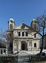
Église Saint Jacques et Saint Christophe de la Villette, façade 01

La Villette (French pronunciation: [la vilɛt] ) was a French commune (municipality) in the Seine département lying immediately north-east of Paris. It was one of four communes entirely annexed by the city of Paris in 1859. Its territory is now located in the 19th arrondissement, but a neighborhood has retained its name: the quartier de La Villette and the Parc de la Villette. A Gallo-Roman village stood here along the Roman road that led north from Lutetia. About 1198 the district was named the Villa Nova Sancti Lazari, in French Ville Neuf Saint-Ladre, the "new village of Saint-Ladre", which referred to the leper hospice dedicated to the lepers' patron Saint Lazare (Ladre); it became Villette-Saint-Ladre-lez-Paris in a document of 1426. In 1790, the Constituent Assembly of Revolutionary France raised the hamlet to the status of a commune.

Excerpt from the Wikipedia article La Villette, Seine (License: CC BY-SA 3.0, Authors, Images).

La Villette, Seine
Rue de Joinville, Paris Quartier de la Villette (Paris)

Geographical coordinates (GPS) Address Nearby Places
placeShow on map

Wikipedia: La Villette, SeineContinue reading on Wikipedia

Geographical coordinates (GPS)

Latitude Longitude
N 48.89 ° E 2.38 °
placeShow on map

Address

Rue de Joinville 14
75019 Paris, Quartier de la Villette (Paris)
Ile-de-France, France
mapOpen on Google Maps

Église Saint Jacques et Saint Christophe de la Villette, façade 01
Share experience

Nearby Places

Bassin de la Villette

The Bassin de la Villette (La Villette Basin) is the largest artificial lake in Paris. It was filled with water on 2 December 1808. Located in the 19th arrondissement of the capital, it links the Canal de l'Ourcq to the Canal Saint-Martin, and it represents one of the elements of the Réseau des Canaux Parisiens (Parisian Canal Network), a public-works authority operated by the city. The other components of the network are the Canal de l'Ourcq, the Canal Saint-Denis, the Canal Saint-Martin, and the Bassin de l'Arsenal. Together, these canals and basins extend roughly 130 kilometres (81 mi). Rectangular, eight hundred metres in length and seventy metres in width, it begins at the Rue de Crimée lifting bridge, the last bridge in Paris that can be raised and lowered hydraulically to permit the passage of ship and barge traffic beneath it, and it ends at the Place de la Bataille-de-Stalingrad near the Rotunda de la Villette. River cruise boats tie-up here and the shores of the basin are also the location of the MK2 Quai de Loire and MK2 Quai de Seine theatre complexes which are the most modern in France. A small electric passenger ferry, the Zéro de conduite, is available for transporting people from one side of the basin to the other. The basin is bordered in the north by the Quai de la Seine and in the south by the Quai de la Loire, which are linked in the middle of the basin by a footbridge, the Passerelle de la Moselle.