place

Pelham Bay Bridge

Amtrak bridgesBascule bridges in the United StatesBridges completed in 1907Bridges in the BronxConcrete bridges in the United States
New York, New Haven and Hartford Railroad bridgesPelham Bay ParkRailroad bridges in New York CitySteel bridges in the United StatesUse mdy dates from November 2017Warren truss bridges in the United States
Hutchinson River Bridge

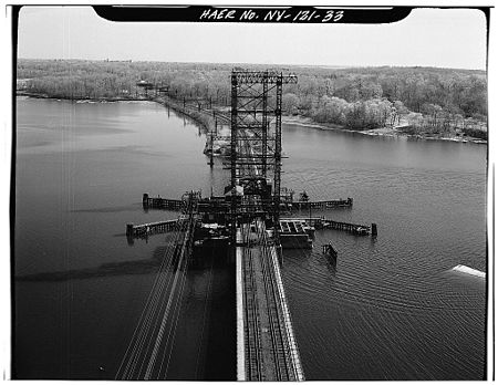
The Pelham Bay Bridge, also known as the Amtrak Hutchinson River Bridge, is a two-track movable railroad bridge that carries the Northeast Corridor (NEC) over the Hutchinson River in the Bronx, New York, upstream from the vehicular/pedestrian Pelham Bridge. It is owned by Amtrak, which provides passenger service, and is used by CSX Transportation and the Providence & Worcester Railroad for freight traffic. The New York, New Haven and Hartford Railroad completed construction of the bridge in 1907. Amtrak partially rehabilitated it in 2009. The bridge is obsolete and requires extensive ongoing maintenance, with speeds restricted to 45 miles per hour (72 km/h). The lift span is manned and required to open on demand; it does so several times per day for commercial boats.Amtrak plans to replace the bridge with a new high-level fixed bridge with clearance for maritime traffic. Preliminary work began in 2013. MTA's Metro-North Railroad has proposed the Penn Station Access using the bridge for a so-called Hell Gate Line service which would allow some New Haven Line trains to access New York Penn Station. In January 2019, Amtrak and the MTA reached an agreement regarding Penn Station Access. As part of the deal, the MTA would pay to replace the Pelham Bay Bridge.

Excerpt from the Wikipedia article Pelham Bay Bridge (License: CC BY-SA 3.0, Authors, Images).

Pelham Bay Bridge
Shore Road, New York The Bronx

Geographical coordinates (GPS) Address External links Nearby Places
placeShow on map

Wikipedia: Pelham Bay BridgeContinue reading on Wikipedia

Geographical coordinates (GPS)

Latitude Longitude
N 40.8634 ° E -73.8179 °
placeShow on map

Address

Pelham Bay Bridge

Shore Road
10475 New York, The Bronx
New York, United States
mapOpen on Google Maps

linkWikiData (Q20880724)
linkOpenStreetMap (522569231)

Hutchinson River Bridge
Share experience

Nearby Places

Battle of Pell's Point

The Battle of Pell's Point (October 18, 1776), also known as the Battle of Pelham, was a skirmish fought between British and American troops during the New York and New Jersey campaign of the American Revolutionary War. The conflict took place in what is now part of Pelham Bay Park (namely the Split Rock Golf Course and Pelham Bay Golf Course) in the Bronx, New York City and the towns of Pelham Manor and Pelham in Westchester County, New York. On October 12, British forces landed at Throgs Neck in order to execute a flanking maneuver that would trap Gen. George Washington, commander-in-chief of the American revolutionary forces, and the main body of the Continental Army on the island of Manhattan. The Americans thwarted the landing, and Gen. Sir William Howe, commander-in-chief of British forces in North America, looked for another location along Long Island Sound to disembark his troops. On October 18, he landed 4,000 men at Pelham, 3 miles (4.8 km) north of Throgs Neck. Inland were 750 men of a brigade under the command of the American Col. John Glover. Glover positioned his troops behind a series of stone walls and attacked the British advance units. As the British overran each position, the American troops fell back and reorganized behind the next wall. After several such attacks, the British broke off, and the Americans retreated. The battle delayed British movements long enough for Washington to move the main army to White Plains and avoid being surrounded on Manhattan. After losing to the British in a battle at White Plains, and losing Fort Washington, Washington retreated across New Jersey to Pennsylvania.

Pelham Bay Park
Pelham Bay Park

Pelham Bay Park is a municipal park located in the northeast corner of the New York City borough of the Bronx. It is, at 2,772 acres (1,122 ha), the largest public park in New York City. The park is more than three times the size of Manhattan's Central Park. The park is operated by the New York City Department of Parks and Recreation (NYC Parks). Pelham Bay Park contains many geographical features, both natural and man-made. The park includes several peninsulas, including Rodman's Neck, Tallapoosa Point, and the former Hunter and Twin Islands. A lagoon runs through the center of Pelham Bay Park, and Eastchester Bay splits the southwestern corner from the rest of the park. There are also several recreational areas within the park. Orchard Beach runs along Pelham Bay on the park's eastern shore. Two golf courses and various nature trails are located within the park's central section. Other landmarks include the Bartow-Pell Mansion, a city landmark, as well as the Bronx Victory Column & Memorial Grove. Before its creation, the land comprising the current Pelham Bay Park was part of Anne Hutchinson's short-lived dissident colony. Part of New Netherland, it was destroyed in 1643 by a Siwanoy attack in reprisal for the unrelated massacres carried out under Willem Kieft's direction of the Dutch West India Company's New Amsterdam colony. In 1654 an Englishman named Thomas Pell purchased 50,000 acres (200 km²) from the Siwanoy, land which would become known as Pelham Manor after Charles II's 1666 charter. During the American Revolutionary War, the land was a buffer between British-held New York City and rebel-held Westchester, serving as the site of the Battle of Pell's Point, where Massachusetts militia hiding behind stone walls (still visible at one of the park's golf courses) stopped a British advance. The park was created in 1888, under the auspices of the Bronx Parks Department, largely inspired by the vision of John Mullaly, and passed to New York City when the part of the Bronx east of the Bronx River was annexed to the city in 1895. Orchard Beach, one of the city's most popular, was created through the efforts of Robert Moses in the 1930s.

Freedomland U.S.A.

Freedomland U.S.A. (usually called Freedomland) was a theme park in the Baychester section of the northeastern Bronx, New York City, dedicated to American history. Operating from 1960 to 1964, Freedomland was built on marshland owned by the Webb and Knapp company, of which William Zeckendorf Sr. was the major owner. Zeckendorf announced his plans for Freedomland in May 1959. The park layout was conceived and built by C. V. Wood, and consisted of over 40 attractions arranged in the shape of a large map of the contiguous United States. Groundbreaking ceremonies for Freedomland occurred in late 1959, and Freedomland opened on June 19, 1960, to large crowds. Due to Freedomland's $65 million cost, the park already faced financial issues at the time of its opening, and by the end of the 1961 season, Freedomland was $8 million in debt. To generate revenue, the park added more exhibits and conventional amusements. By 1963, further financial issues led the owners to sell off a portion of Freedomland's lot to a pension fund of the Teamsters Union, as well as close off a section of the park. Even though Freedomland's planners anticipated that the park would eventually be developed into a full-time amusement area, it closed for the last time at the end of the 1964 season. On September 14, 1964, Freedomland filed for bankruptcy. In the late 1960s and early 1970s, the site of Freedomland was redeveloped as Co-op City, the world's largest housing cooperative. Also built on the site were the Bay Plaza Shopping Center and an indoor mall. Many Freedomland attractions and design features were auctioned or sold to other parks, and many of these rides no longer exist. While little physical evidence of Freedomland remains, several media works commemorate the former amusement park.