Leigh, Staffordshire
Borough of East StaffordshireCivil parishes in StaffordshireUse British English from May 2015Villages in Staffordshire

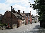
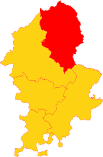
Leigh is a civil parish in the English county of Staffordshire. The parish includes the village of Church Leigh, together with the settlements of Withington, Upper Leigh, Lower Leigh, Morrilow Heath, Middleton Green, Dodsley, Godstone, Nobut and Field. Church Leigh is 6.2 miles (10.0 km) WNW of the town of Uttoxeter, 14.3 miles (23.0 km) north east of Stafford and 148 miles (238 km) north west of London. The other settlements are within 3 miles (4.8 km) of Church Leigh. The population of Leigh is stable at around 900.
Excerpt from the Wikipedia article Leigh, Staffordshire (License: CC BY-SA 3.0, Authors, Images).Leigh, Staffordshire
Bagots View, East Staffordshire Leigh
Geographical coordinates (GPS) Address Nearby Places Show on map
Geographical coordinates (GPS)
| Latitude | Longitude |
|---|---|
| N 52.919978 ° | E -1.965834 ° |
Address
All Saints Church
Bagots View
ST10 4PT East Staffordshire, Leigh
England, United Kingdom
Open on Google Maps


