place

Twente

Regions of OverijsselRegions of the NetherlandsTwente
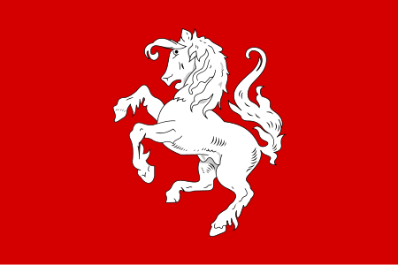
Flag of Twente
Flag of Twente

Twente (Dutch: Twente [ˈtʋɛntə], Tweants dialect: Tweante) is a region in the eastern Netherlands. It encompasses the most urbanised and easternmost part of the province of Overijssel. Twente is most likely named after the Tuihanti or Tvihanti, a Germanic tribe that settled in the area and was mentioned by the Roman historian Tacitus. The region's borders are defined by the Overijssel region of Salland in the northwest and west (the river Regge roughly defines the western border), the German County of Bentheim in the northeast and east (the river Dinkel roughly defines the eastern border) and the Gelderland region of the Achterhoek in the south. Twente has approximately 620,000 inhabitants, most of whom live in its three largest cities: Almelo, Hengelo and Enschede, the latter being the main city of the region. It comprises fourteen municipalities: Almelo, Borne, Dinkelland, Enschede, Haaksbergen, Hellendoorn, Hengelo, Hof van Twente, Losser, Oldenzaal, Rijssen-Holten, Tubbergen, Twenterand and Wierden. The whole of Hellendoorn and the western parts of both Rijssen-Holten and Twenterand historically belong to the cultural region of Salland, but to the city region of Twente.

Excerpt from the Wikipedia article Twente (License: CC BY-SA 3.0, Authors, Images).

Twente
Hertmerweg, Dinkelland

Geographical coordinates (GPS) Address Nearby Places
placeShow on map

Wikipedia: TwenteContinue reading on Wikipedia

Geographical coordinates (GPS)

Latitude Longitude
N 52.321666666667 ° E 6.7702777777778 °
placeShow on map

Address

Hertmerweg 5
7597 NP Dinkelland
Overijssel, Netherlands
mapOpen on Google Maps

Flag of Twente
Flag of Twente
Share experience

Nearby Places

Azelo
Azelo

Azelo (Dutch pronunciation: [ˈaː.zəˌloː]; Tweants: Oazel(e)) is a hamlet in the municipalities of Hof van Twente, Borne, and Almelo in the province of Overijssel in the Netherlands. It is located between Borne, Bornerbroek, and Delden and has approximately 250 inhabitants. Until January 1, 2001, Azelo belonged largely to the municipality of Ambt Delden. The hamlet is particularly known for the Azelo junction, where the A1 motorway and the A35 motorway meet. The Azelerbeek flows east of the center of Azelo. The hamlet was first attested as Aselo in 1333. The name is likely a compound of Old Dutch Aso (a personal name) and lo ("light forest"). Azelo used to be a hamlet and marke in the richterambt of Delden. The erfmarkenrichterschap of marke Azelo was originally located on the Hof van Azelo, the current farms of Have and Meijer. After Twickel bought the markenrichterschap in the seventeenth century, the meetings were usually kept on the Graes farm. The manor of Dubbelink used to be located in the hamlet of Azelo. A remnant of this is the so-called Meistershoes ('Master's House') on the Meijerinkveldkampsweg. The old Dubbelink bakehouse also still exists. A large number of the farms in Azelo, including Graes, Grave, Morskate, and the farms on Dubbelink, belong to the Twickel estate. The hamlet's area has a large spread size, and is located in three different municipalities. This is mainly due to a boundary correction during the 2001 reorganization, in which the municipal boundaries were located along the A1 motorway. Because of this, a third of the hamlet is partly in the municipality of Borne and partly in the municipality of Almelo. The vast majority, however, is located in the municipality of Hof van Twente, which is also indicated on the place name sign of the hamlet.