place

Norton railway station (Cheshire)

Disused railway stations in the Borough of HaltonFormer Birkenhead Railway stationsNorth West England railway station stubsPages with no open date in Infobox stationRailway stations in Great Britain closed in 1952
Railway stations in Great Britain opened in 1850Use British English from December 2016
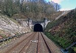
Norton railway station (site), Cheshire (geograph 4339737)

Norton railway station was a station near Norton, a village to the east of Runcorn, Cheshire, England. It was located just north of the 1.25 mile (2 km) Sutton Tunnel and was built as a result of the recommendations of a Board of Trade enquiry into a fatal accident in the tunnel the previous year. It was opened by the Birkenhead, Lancashire & Cheshire Joint Railway company on 18 December 1850; originally named Norton, it was renamed Norton (Cheshire) in 1926; and it was closed to passenger traffic by the British Transport Commission on 1 September 1952. Most of the station has since been demolished, but the old station house remains in use as a private dwelling and there is a signal box nearby that still bears this name. A new station, known as Runcorn East was opened a few metres south of the original site in October 1983 to serve the southern end of Runcorn new town.

Excerpt from the Wikipedia article Norton railway station (Cheshire) (License: CC BY-SA 3.0, Authors, Images).

Norton railway station (Cheshire)
Norton Station Road,

Geographical coordinates (GPS) Address Nearby Places
placeShow on map

Wikipedia: Norton railway station (Cheshire)Continue reading on Wikipedia

Geographical coordinates (GPS)

Latitude Longitude
N 53.3295 ° E -2.6638 °
placeShow on map

Address

Norton Station Road
WA7 6PY , Murdishaw
England, United Kingdom
mapOpen on Google Maps

Norton railway station (site), Cheshire (geograph 4339737)
Share experience

Nearby Places

Preston Brook railway station

Preston Brook railway station was a station on the Grand Junction Railway serving the villages of Preston Brook and Preston on the Hill in what was then Cheshire, England. It opened on 4 July 1837 when the line opened.The station is located in a cutting on the south side of the Warrington to Chester turnpike (which is now Chester Road, the A56). The road crossed the railway on an over-bridge, with a ramp down to the station building on the down, western, side of the tracks. Initially there were no platforms and a single storey hipped roof building.By 1898 the station had platforms and the main building on the down platform had been enlarged, this platform was still accessed via a ramp. On the up platform there were some buildings, probably a shelter, and steps down from the road.In the early days there were two mixed trains in each direction, times changed from year to year. The station closed to passengers and parcels on 1 March 1948 but it continued in use for railway workers until 1963. April 1952Goods facilities were a little remote from the station being approximately 500 yards (460 m) south of the station, they consisted of a goods shed and several trans-shipment sidings between the mainline and the associated Manchester Ship Canal Company's Bridgewater siding to the east. The goods yard was equipped for general goods and livestock with a 1½ ton crane. The goods yard closed on 1 September 1958.The line is still open, other than a station house, no substantive remains exist as of 2016.