place

St. Volodymyr's Ukrainian Orthodox Cathedral (Toronto)
20th-century Eastern Orthodox church buildings20th-century churches in CanadaCanadian church stubsChurch buildings with domesChurches completed in 1948
Churches in TorontoEastern Orthodox church stubsUkrainian-Canadian culture in OntarioUkrainian Orthodox Church of Canada cathedrals
St Volodymyr's (Toronto)

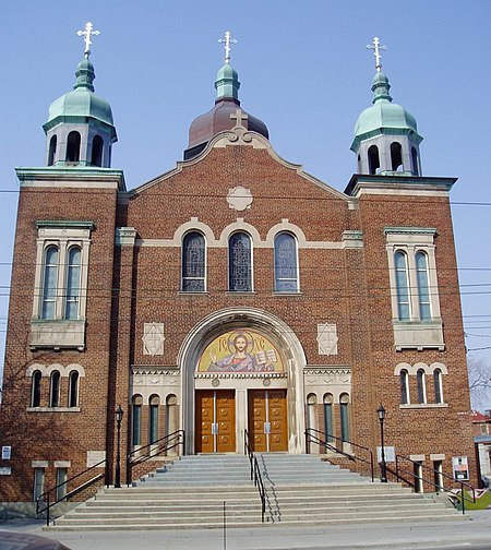
St. Volodymyr's Ukrainian Orthodox Cathedral is a Ukrainian Orthodox Cathedral in Toronto, Ontario, Canada located on Bathurst Street just to the west of Kensington Market. The majority of the first Ukrainian immigrants to Canada were Eastern Catholic believers with only a small fraction belonging to the Eastern Orthodox faith. This changed with later waves of immigration that saw more people coming from the Orthodox east. The first Ukrainian Orthodox Union in Toronto was established in 1926. For several years they met in rented halls and in churches of other denominations. The land on Bathurst was purchased in 1935. Work on the cathedral began in 1946 and was completed two years later. The cathedral is in the standard Byzantine style used throughout Ukraine.

Excerpt from the Wikipedia article St. Volodymyr's Ukrainian Orthodox Cathedral (Toronto) (License: CC BY-SA 3.0, Authors, Images).

St. Volodymyr's Ukrainian Orthodox Cathedral (Toronto)
Bathurst Street, Toronto

Geographical coordinates (GPS) Address Phone number Website External links Nearby Places
placeShow on map

Wikipedia: St. Volodymyr's Ukrainian Orthodox Cathedral (Toronto)Continue reading on Wikipedia

Geographical coordinates (GPS)

Latitude Longitude
N 43.653845 ° E -79.406932 °
placeShow on map

Address

St. Volodymir Ukrainian Orthodox Cathedral

Bathurst Street 400
M5T 2S6 Toronto
Ontario, Canada
mapOpen on Google Maps

Phone number

call+14166033224

Website
stvolodymyr.ca

linkVisit website

linkWikiData (Q7592132)
linkOpenStreetMap (54965504)

St Volodymyr's (Toronto)
Share experience

Nearby Places

Trinity—Spadina (provincial electoral district)

Trinity—Spadina was a provincial electoral district in Ontario, Canada, that was represented in the Legislative Assembly of Ontario since 1999. The electoral district was created in 1999 when provincial ridings were defined to have the same borders as federal ridings. It generally encompasses the western portion of Downtown Toronto. In the 2001 Canadian census, the riding had 106,094 people of which 74,409 were eligible to vote. Its Member of Provincial Parliament (MPP) elect is Chris Glover of the Ontario New Democratic Party, who unseated short lived MPP Han Dong in the 2018 general election. Major landmarks within the riding include the western portion of the University of Toronto, the CN Tower, Rogers Centre (formerly Skydome), Air Canada Centre, the Canadian Broadcasting Centre, 299 Queen Street West, the Toronto Eaton Centre, the Metro Toronto Convention Centre, Toronto City Hall, Kensington Market, Chinatown, Christie Pits, Trinity Bellwoods Park and Palmerston Boulevard. The riding is one of the most ethnically diverse in Canada containing the heart of Toronto's Chinatown, Koreatown, Little Italy and Little Portugal. The northern section of the riding is the trendy Annex district, while the eastern edge contains part of the University of Toronto and thousands of students. The riding has been the most left-leaning in Toronto and has voted NDP provincially for a number of years. In 2018, the district was dissolved into Spadina—Fort York, University—Rosedale and Toronto Centre.

Palmerston Boulevard

Palmerston Boulevard is a residential street located in the city of Toronto, Ontario, Canada, two blocks west of Bathurst Street, between Koreatown and Little Italy. Bounded by stone and iron gates both at Bloor Street and College Street, lined by symmetrically placed cast-iron lamps and canopied by mature silver maple trees, Palmerston is one of Toronto's finest residential streets. The name Palmerston continues south as Palmerston Avenue from College Street to Queen Street. Formerly called Muter Street, the street's name was changed to Palmerston at the turn of the 20th century, as it was developed. Muter Street was named after Lieutenant-Colonel Robert Muter of the Royal Canadian Rifle Regiment. Palmerston was named after Lord Palmerston, Prime Minister of the United Kingdom, perhaps to promote Victorian ideals to future Torontonians.Most of the houses on Palmerston Boulevard were built between 1903 and 1910. An architectural analysis of the Boulevard was published in 1982. Palmerston Boulevard: An Evaluation of a Unique Residential Street written by landscape architects Brown+Storey covers the evolution of the street, its landscape, built form, critical evaluation of renovations, and key landscape items such as trees, porches, street lights and the gates. It also contains a comparison of Toronto streets built around the same time with Palmerston compared to Indian Road, St. George Street and High Park Boulevard. Brown+Storey place great emphasis on Palmerston's trees and lamps - "The trees and street lamps define the space of the Boulevard as a passage."The grandest house on the street is #469, the George Weston Mansion, built on 1.5 lots. Weston died in 469 Palmerston Boulevard on April 6, 1924. Former Mayors of Toronto Horatio Hocken and Samuel McBride lived at #340 and #351 respectively. Palmerston Boulevard was initially a wealthy Anglo-Saxon enclave. From the 1920s to the 1950s, the street was made up primarily of middle- and upper-middle-class Jews who were often excluded from elite WASP neighbourhoods. In the 1960s, some of the houses were subdivided into rooming houses that served university students.