place

Aburrá Valley

Drainage basins of South AmericaThe Metropolitan Area of the Aburrá ValleyValleys of Colombia
Mapa del área metropolitana del Valle de Aburrá

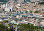
Aburrá Valley (in Spanish Valle de Aburrá), is the natural river basin of the Medellín River and one of the most populous valleys of Colombia in its Andean Region with near 4 million inhabitants in its biggest urban agglomeration: The Metropolitan Area of the Aburrá Valley. The valley is located on the Central Range, over the Antioquian Mountain just between the Magdalena and Cauca valleys from east to west. The name "Aburrá" comes from an ancient language spoken in the place by the "Aburreans" (Aburraes) before the Spaniards settled the place during the 16th century. The valley is oriented from south to north being the south the highest level and the north the low level. The altitudes of the mountains around the valley (west and east mountains), can reach up to 3,100 m (10,200 ft) above the sea level (Padre Amaya Peak). The lowest level is 1,300 m (4,300 ft) above the sea level. From its north natural limit to its southern part, the valley is 60 km (37 mi) long, while there are several varieties in its width being the wider part the one that corresponds to the municipality of Medellín with 8–10 km (5.0–6.2 mi) and the narrowest the part that corresponds to the municipality of Copacabana with 3 km (1.9 mi).

Excerpt from the Wikipedia article Aburrá Valley (License: CC BY-SA 3.0, Authors, Images).

Aburrá Valley
Calle 31, Medellín Comuna 10 - La Candelaria (Perímetro Urbano Medellín)

Geographical coordinates (GPS) Address Nearby Places
placeShow on map

Wikipedia: Aburrá ValleyContinue reading on Wikipedia

Geographical coordinates (GPS)

Latitude Longitude
N 6.2319 ° E -75.5681 °
placeShow on map

Address

Calle 31

Calle 31
050016 Medellín, Comuna 10 - La Candelaria (Perímetro Urbano Medellín)
Antioquia, Colombia
mapOpen on Google Maps

Mapa del área metropolitana del Valle de Aburrá
Share experience

Nearby Places

Integrated urban water management in Medellín

Integrated urban water management in Medellín, Colombia is considered to be an overall success and a good example of how a large metropolitan area with moderate income disparity can adequately operate and maintain quality water supply to its many citizens. This is quite remarkable given the large urbanized population in the metropolitan area of the Aburrá Valley of 3.3 million, many of whom live on the slopes of the Aburrá Valley where Medellín is situated and highly prone to landslides and stormwater erosion. Sound urban water management within the metropolitan area of the Aburrá Valley is carried out by a set of technically strong institutions with financial independence—and lack of political interference such as Empresas Publicas de Medellin (EPM).The metropolitan area of the Aburrá Valley is located near the equator but with a high elevation, the average climate is quite mild without great variation in temperature and rainfall. Consistent and adequate precipitation in the surrounding basins usually ensures that nearby water basins feeding the Aburrá Medellín River basin and subsequently the MAM can store approximately 178 BCM of water for the Metropolitan Area of the Aburrá Valley. Adequate supply and good resource management has allowed nearly 100% of MAM citizens across ten municipalities to receive piped water. Substantial challenges remain however for Colombia's second largest urban and economical center in dealing with an increasing urbanization rate and the settling of inhabitants higher up the hillsides within the narrow valley. Drainage of stormwater is probably the most significant concern for the Metropolitan Area of the Aburrá Valley government and managing institutions. A stormwater management plan has been instituted to help address the adverse effects of urbanization, lack of infrastructures in poorer neighborhoods able to handle stormwater, river conservation and risk assessment.