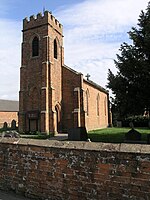
Edlaston
Derbyshire DalesDerbyshire geography stubsTowns and villages of the Peak DistrictVillages in Derbyshire

Edlaston is a village three miles south of Ashbourne in Derbyshire, just off the A515 road. It is in close proximity to the hamlet of Wyaston, and the civil parish is called Edlaston and Wyaston. It had a population of 220 at the 2011 Census.It is very rural as the land is light and stony with a clay subsoil, which is suitable for dairy pasture. The village consists of a few farms and cottages and a traditional stone built public house The Shire Horse on the outer east edge of the village. To the west of the village is Edlaston Hall. It and its outbuildings have been converted to multiple dwellings.
Excerpt from the Wikipedia article Edlaston (License: CC BY-SA 3.0, Authors, Images).Edlaston
Edlaston Lane, Derbyshire Dales Edlaston and Wyaston CP
Geographical coordinates (GPS) Address Nearby Places Show on map
Geographical coordinates (GPS)
| Latitude | Longitude |
|---|---|
| N 52.981 ° | E -1.73 ° |
Address
Edlaston Lane
Edlaston Lane
DE6 2DQ Derbyshire Dales, Edlaston and Wyaston CP
England, United Kingdom
Open on Google Maps


