place

Pilsley railway station

Disused railway stations in DerbyshireEast Midlands railway station stubsFormer Great Central Railway stationsPages with no open date in Infobox stationRailway stations in Great Britain closed in 1959
Railway stations in Great Britain opened in 1893Use British English from May 2017
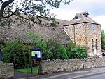
Station masters house, pilsley geograph.org.uk 328682

Pilsley railway station was a station in the village of Pilsley in Derbyshire. The station was opened on 2 January 1893 by the Manchester, Sheffield and Lincolnshire Railway (later part of the Great Central Railway and subsequently the LNER), on its line from Beighton in the outskirts of Sheffield to Annesley in Nottinghamshire, which later became part of the Great Central main line to London. Along much of the route between Sheffield and Nottingham the line ran through a mainly industrial landscape dominated by mining. Pilsley had its own colliery a short distance to the north of the station, with extensive sidings on both sides of the main line. The Midland Railway also gained access to Pilsley colliery, via a section about 2.5 miles in length which branched off their Erewash Valley Line just to the north of Doe Hill station, and ran across country to join the Great Central at Pilsley, running virtually alongside Pilsley station before making its connection with the line near the colliery. Pilsley station closed on 2 November 1959, the line itself on 5 September 1966. The collieries also closed around this time, although coal mining continued to be a source of employment for the village until the 1980s. The route of the Great Central line was redeveloped by Derbyshire County Council in the late 1960s and early 1970s, and now forms part of the Five Pits Trail network. These efforts received a Countryside Award in 1970, as indicated by a plaque at the site of Pilsley station. The trail runs approximately 12 miles, from Tibshelf to Grassmoor Country Park, though with the filling in of cuttings and removal of embankments it is virtually unrecognisable as a former railway line. Similarly the collieries that had once been such conspicuous features of the landscape have vanished without trace. The area is now once again mostly rural in character.

Excerpt from the Wikipedia article Pilsley railway station (License: CC BY-SA 3.0, Authors, Images).

Pilsley railway station
Station Road, North East Derbyshire Pilsley

Geographical coordinates (GPS) Address Nearby Places
placeShow on map

Wikipedia: Pilsley railway stationContinue reading on Wikipedia

Geographical coordinates (GPS)

Latitude Longitude
N 53.1572 ° E -1.3588 °
placeShow on map

Address

Station Road

Station Road
S45 8BH North East Derbyshire, Pilsley
England, United Kingdom
mapOpen on Google Maps

Station masters house, pilsley geograph.org.uk 328682
Share experience

Nearby Places

Pilsley, North East Derbyshire

Pilsley is a rural village and civil parish in North East Derbyshire, near Chesterfield. At the 2011 Census the population was 3,487. Pilsley consists of two distinct residential areas known as Lower Pilsley and Pilsley (sometimes Upper Pilsley). Lower Pilsley being the northern residential area and Pilsley being the southern residential area. There is some local disagreement as to whether these two areas constitute two separate villages or one larger village. At the start of the village's life, people referred to the area around what is now Pilsley primary as Nether Pilsley. Both areas of the village are united by the same parish council, Pilsley Parish Council, which was formed on 30 January 1874; Pilsley having previously been part of the parish of North Wingfield. Maps show that the village is made up of four separate residential areas, which are, in order of their north to south alignment, Lower Pilsley, Upper Pilsley, Pilsley and Nether Pilsley.Pilsley has an Anglican church, St Mary's, an evangelical Methodist church, two primary schools, a post office and a Kingdom Hall building for Jehovah's Witnesses. Pilsley also has a Village Hall and St Mary's Centre (formerly the church hall). Recently a new sports centre (The Elm Centre) was built for the school which is also available for community use. A section of the Midland Main Line (Nottingham to Chesterfield section) runs along the western edge of the village. A branch of the Great Central Railway ran through the village prior to the Beeching cuts of the 1960s, with a station sited on Station Road. The route of this former railway line now serves as a popular walking, cycling and horse riding trail known as the Five Pits Trail, linking Pilsley to Tibshelf, Holmewood, Grassmoor and beyond. Pilsley has a Sunday league football team called Pilsley Miners Welfare Football Club. The team is currently part of the Chesterfield and District Sunday League. There is also a cricket team which play on the welfare, made famous by Jason Clayton, there is even a end of the pitch called “the Clayton end” from which the star bowls from. The source of the River Rother is at Pilsley. Although it is not possible to see Chesterfield from the residential part of upper Pilsley, the famous twisted spire of the Church of St Mary and All Saints in Chesterfield can be seen from part of Locko Road (near the junction with Dale View Road) in Lower Pilsley, and from two specific places in the Pilsley area. Locko plantation (planted 1976) has a 15m wide strip without trees on the side facing Green Lane, this has been left clear to provide a view of the Chesterfield spire; however, it can only be seen from the top 20m of the plantation; it is most easily seen at night when the spire is floodlit. The second place where the spire can be seen is on the Five Pits Trail, about 300m north of the Timber Lane car park; the spire can be seen along an 18m length of the path through a gap between a row of houses in the Highfields area of North Wingfield.

Tibshelf Town railway station

Tibshelf Town railway station is a disused station on the former Great Central Main Line in the village of Tibshelf in Derbyshire, England. The station was opened on 2 January 1893 by the Manchester, Sheffield and Lincolnshire Railway (later part of the Great Central Railway and subsequently the LNER), on its line from Beighton in the outskirts of Sheffield to Annesley in Nottinghamshire, which later became part of the Great Central main line to London. The station was optimistically designated Tibshelf Town, reflecting Tibshelf's aspirations to obtain official town status. Tibshelf never did become a town but the station kept this name throughout its operating life. The line ran through a mainly industrial landscape dominated by mining. To the north of the station was a deep cutting where a tunnel was originally intended; fears of damage through mining subsidence forced the change in the plans. Tibshelf High Street crossed a bridge over this cutting. To the south, the line crossed over the Midland Railway's branch line from Westhouses & Blackwell (on the Erewash Valley Line), to Mansfield Woodhouse, just to the east of their own Tibshelf & Newton station. This line closed to passengers on 28 July 1930 but remained in use for freight and coal trains long afterwards; the route is now a footpath but Tibshelf & Newton station still stands. Tibshelf Town station closed on 4 March 1963, the line itself on 5 September 1966. The collieries also closed around this time, although coal mining continued to be a major source of employment for the village, with around 2,000 of Tibshelf's inhabitants still working at local pits as late as the 1980s. The route of the Great Central line was redeveloped as a recreational route by Derbyshire County Council in the late 1960s and early 1970s, and now forms part of the Five Pits Trail network. These efforts received a Countryside Award in 1970, as indicated by a plaque at nearby Pilsley where the next station northwards was sited. The trail runs approximately 12 miles, from Tibshelf to Grassmoor Country Park, though with the filling in of cuttings and removal of embankments it is virtually unrecognisable as a former railway line. Similarly the collieries that had once been such conspicuous features of the landscape have vanished without trace. The area is now once again mostly rural in character.

Astwith
Astwith

Astwith is a village in Derbyshire, England. Astwith is in the parish of Ault Hucknall. For many decades it was a part of the manor of Stainsby, which was known as Steinesbei in the Domesday survey (1087). Apparently there is no mention of Astwith, otherwise spelt Estewayt, Est(th)wayt, Estweit and Eswheyt, by name until the 13th century. This extract was taken from a small book found in the Chesterfield library written by J.E.Milner a local schoolmaster: "There is no mention of it (Astwith) until the 1200s when Adeluga, widow of Robert le Sauvage, released among other bequests, one messuage and one bovate of land at Estewyte to John de Sauvage and his heirs. It would also suggest that between the two claims for the name's meaning: a. the ford by the ash trees b. The East ford the latter seems the more likely. The ford, now a bridge, is on the lane from Stainsby, but east of where, remains a puzzle." The Savage family are believed to have held Astwith among other local lands until 1593, when Bess of Hardwick purchased them from the Lord Chancellor and Auditor for the sum of £9,500. Following her death, her son William 1st Lord Cavendish, had a survey of all his lands carried out by William Senior in 1609/1610. At this time Astwith is recorded with a total acreage of 508 acres (2.06 km2) and seven named residents. These were Matthewe Foxe, Richard Carman, Henrie Frithe, John Tacie, John Turner, Robert Wainwrighte, Humphrie Fretwell. These residents had holdings varying in size from 88 acres (360,000 m2) to just over 1-acre (4,000 m2). The common extended to 169 acres (0.68 km2), and the cunygre to a further 24 acres (97,000 m2). Unlike other local villages which were built along a main street with tofts on either side, Astwith was ranged along the edge of the common. By the time of the 1839 Tithe Awards, the village had grown to 17 households, although the acreage farmed had remained the same in total. Communications to local towns had been improved by the development of the turnpike road between Tibshelf and Temple Normanton in the 1820s. Access roads into the village from the turnpike were improved and the housing centre of the village moved to this access road. The village remained in the ownership of the Dukes of Devonshire until 1959, when it was passed to the National Trust as part of the death duty settlement of the 10th Duke. Most of the village is now in private ownership, after the National Trust began to dispose of its holding of residential buildings in the 1970s. The Trust retains much of the land which is farmed by the one working farm in the village or by the farm at Hardwick Park within the grounds of Hardwick Hall which they run in partnership with the farmer. Many of the properties in the village remain under building covenants held by the Trust. The photograph looks east and shows Manor Farm Cottage on the right and parts of Manor Farm and The Swallows on the left. There are around 20 homes in Astwith today. There is no room for six bedroom Swiss cottages. Astwith is one of 27 conservation areas within the council area of Bolsover District Council. In October 2010 the Local Conservation Plan for Astwith was approved by Bolsover District Council and a copy of the report can be viewed on their website www.bolsover.gov.uk. A circular walk of around 5.5 miles (8.9 km) is centred on Astwith and is a part of the longer Five Pits Trail which connects Tibshelf, Holmewood and Grassmoor.

Stonebroom
Stonebroom

Stonebroom is a village in the district of North East Derbyshire in Derbyshire, England. It is in the civil parish of Shirland and Higham. Stonebroom lies to the east of the A61 between Alfreton and Clay Cross. It has a primary, nursery, pre-school and two churches, one Church of England and one Methodist. Five households are listed for Stonebroom in the 1841 Census (Shirland Parish) with a sixth listed separately under Pasture House which is part of the village. A directory from 1846 does not mention Stonebroom but one from 1857 acknowledges it and only gives the names of four farmers resident there. A directory from 1895 describes it as "a considerable village – it is a typical colliery village, and has sprung into existence in recent years". In the mid-19th century, houses were built for colliery workers and were called 'the blocks'. These were blocks of eight terraced houses with 160 dwellings. They were condemned before 1939 but still there in 1947 and described by the Derbyshire Times as "The Black Hole of Derbyshire". In 1950 they were demolished but the area of wasteland was known as The Blocks by the locals. From the 1970s new housing and industrial estates were built on the land. Meanwhile, a massive housing estate had already been established in the "upper" area of Stonebroom. The village is linear and was formed from two hamlets; early maps show them as Upper Stone and Lower Stone. The school playing field was once the site of a quarry, and is still called Quarry Lane. It is probable that the name Stonebroom was derived from this quarry which provided stone; it is said that the field behind the quarry was full of broom, which gave one possible explanation for the unusual village name. Another report states that the Roman Stan Brom means quarry.