Pepinster
Liège geography stubsMunicipalities of Liège ProvincePepinster

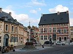
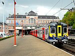
Pepinster (French pronunciation: [pepɛ̃stɛʁ] or [pəpɛ̃stɛʁ]) is a municipality of Wallonia located in the province of Liège, Belgium. On 1 January 2006 Pepinster had a total population of 9,560. The total area is 24.79 km2 which gives a population density of 386 inhabitants per km2. Pepinster is situated at the confluence of the rivers Hoëgne and Vesdre. The municipality consists of the following districts: Cornesse, Pepinster (including the hamlet of Tancrémont), Soiron, and Wegnez. Pepinster was hit extremely hard by the 2021 European floods, the village was temporarily cut off from roads.
Excerpt from the Wikipedia article Pepinster (License: CC BY-SA 3.0, Authors, Images).Pepinster
Chemin Tchepson,
Geographical coordinates (GPS) Address Nearby Places Show on map
Geographical coordinates (GPS)
| Latitude | Longitude |
|---|---|
| N 50.566666666667 ° | E 5.8166666666667 ° |
Address
Chemin Tchepson
Chemin Tchepson
4860
Liège, Belgium
Open on Google Maps


