South Forty-Foot Drain

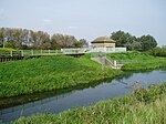
The South Forty-Foot Drain, also known as the Black Sluice Navigation, is the main channel for the land-drainage of the Black Sluice Level in the Lincolnshire Fens. It lies in eastern England between Guthram Gowt and the Black Sluice pumping station on The Haven, at Boston. The Drain has its origins in the 1630s, when the first scheme to make the Fen land available for agriculture was carried out by the Earl of Lindsey, and has been steadily improved since then. Water drained from the land entered The Haven by gravity at certain states of the tide until 1946, when the Black Sluice pumping station was commissioned. The Drain was navigable until 1971, when improvements to the pumping station led to the entrance lock being removed. It is currently being upgraded to navigable status by the Environment Agency, as part of the Fens Waterways Link, with a new entrance lock being completed in December 2008, giving access to the first 12 miles (19 km) of the drain, and the upgrading of the southern section, including a link to the River Glen to allow navigation to Spalding forming phase 2 of the project.
Excerpt from the Wikipedia article South Forty-Foot Drain (License: CC BY-SA 3.0, Authors, Images).South Forty-Foot Drain
Kingston's Bridge, South Kesteven
Geographical coordinates (GPS) Address Nearby Places Show on map
Geographical coordinates (GPS)
| Latitude | Longitude |
|---|---|
| N 52.8494 ° | E -0.27571 ° |
Address
Kingston's Bridge
Kingston's Bridge
PE10 0TX South Kesteven
England, United Kingdom
Open on Google Maps

