Turiec Basin
Landforms of SlovakiaSlovakia geography stubsVáh basinWestern Carpathians

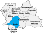
The Turiec Basin (Slovak: Turčianska kotlina; Hungarian: Túróci-medence; German: Turzbecken; Latin: Pelvis Thuroczae) is located in the northern part of central Slovakia, within the Fatra-Tatra Area of the Inner Western Carpathians. The basin is delimited by the mountain ranges of Veľká Fatra to the east, Malá Fatra to the west and north, as well as Žiar and Kremnica Mountains to the south. The Turiec River flows through the entire basin and inflows into Váh near Vrútky. The largest towns are Martin, Vrútky (both part of the Martin District) and Turčianske Teplice (part of the Turčianske Teplice District).
Excerpt from the Wikipedia article Turiec Basin (License: CC BY-SA 3.0, Authors, Images).Turiec Basin
Geographical coordinates (GPS) Address Nearby Places Show on map
Geographical coordinates (GPS)
| Latitude | Longitude |
|---|---|
| N 49.03 ° | E 18.92 ° |
Address
038 40 (Žabokreky)
Region of Žilina, Slovakia
Open on Google Maps


