Empire Corridor

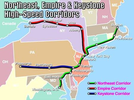
The Empire Corridor is a 461-mile (742 km) passenger rail corridor in New York State running between Penn Station in New York City and Niagara Falls, New York. Major cities on the route include Poughkeepsie, Albany, Schenectady, Amsterdam, Utica, Syracuse, Rochester, and Buffalo. Much of the corridor was once part of the New York Central Railroad's main line. Amtrak's Empire Service and Maple Leaf serve the entire length of the Empire Corridor, with the Maple Leaf continuing northwest to Toronto. The Lake Shore Limited follows most of the corridor from New York City, diverging west to Chicago at Buffalo–Depew station. The Berkshire Flyer takes the corridor to Albany–Rensselaer before diverging east to Pittsfield, while the Adirondack and Ethan Allen Express travel one stop further to Schenectady before diverging north to Montreal and Burlington, respectively. Metro-North Railroad's Hudson Line merges with the Empire Corridor in Spuyten Duyvil, Bronx, just south of Riverdale, providing commuter rail service between Poughkeepsie, New York and Grand Central Terminal. The line is electrified by both overhead catenary and top-running third rail on the Amtrak-owned segment between Penn Station and 41st Street, and by under-running third rail on the Metro-North segment, from the merge with the Hudson Line to Croton–Harmon. The Amtrak-owned section between 41st Street and the merge with the Hudson Line is unpowered and can only be served by diesel or dual-mode trains. The corridor is also one of ten federally designated high-speed rail corridors in the United States. If the proposed high-speed service were built on the corridor, trains traveling between Buffalo and New York City would travel at speeds of up to 125 mph (201 km/h). In the 1890s, the Empire State Express between New York City and Buffalo was about 1 hour faster than Amtrak's service in 2013. On September 14, 1891, the Empire State Express covered the 436 miles (702 km) between New York City and Buffalo in 7 hours and 6 minutes (including stops), averaging 61.4 mph (98.8 km/h), with a top speed of 82 mph (132 km/h).
Excerpt from the Wikipedia article Empire Corridor (License: CC BY-SA 3.0, Authors, Images).Empire Corridor
Central Avenue, City of Rochester
Geographical coordinates (GPS) Address Nearby Places Show on map
Geographical coordinates (GPS)
| Latitude | Longitude |
|---|---|
| N 43.163222222222 ° | E -77.608027777778 ° |
Address
Central Avenue
14605 City of Rochester
New York, United States
Open on Google Maps


