place

Oregon Dunes National Recreation Area

1972 establishments in OregonDunes of the United StatesLandforms of Coos County, OregonLandforms of Douglas County, OregonLandforms of Lane County, Oregon
National Recreation Areas of the United StatesOregon CoastProtected areas established in 1972Protected areas of Coos County, OregonProtected areas of Douglas County, OregonProtected areas of Lane County, OregonProtected areas of OregonSandboarding locationsSiuslaw National Forest
USA Oregon Dunes
USA Oregon Dunes

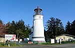
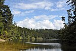
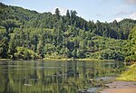
The Oregon Dunes National Recreation Area is located on the Oregon Coast, stretching approximately 40 miles (64 km) north of the Coos River in North Bend to the Siuslaw River in Florence, and adjoining Honeyman State Park on the west. It is part of Siuslaw National Forest and is administered by the United States Forest Service. The Oregon Dunes are a unique area of windswept sand. They are the largest expanse of coastal sand dunes in North America and one of the largest expanses of temperate coastal sand dunes in the world, with some dunes reaching 500 feet (150 m) above sea level. They are the product of millions of years of erosion by wind and rain on the Oregon Coast. There are about 7,000 acres (28 km2) of sand dunes, about a fifth of the total area of the national recreation area. The Oregon Dunes National Recreation Area provides numerous recreational activities, including off-highway vehicle (OHV) use, hiking, fishing, canoeing, horseback riding, and camping. The Carter Dunes Trail and Oregon Dunes Day Use provide forest access for the disabled. Frank Herbert's science-fiction novel Dune was inspired (in part) by the author's research on and fascination with the area.

Excerpt from the Wikipedia article Oregon Dunes National Recreation Area (License: CC BY-SA 3.0, Authors, Images).

Oregon Dunes National Recreation Area

Geographical coordinates (GPS) Address Nearby Places
placeShow on map

Wikipedia: Oregon Dunes National Recreation AreaContinue reading on Wikipedia

Geographical coordinates (GPS)

Latitude Longitude
N 43.724166666667 ° E -124.1775 °
placeShow on map

Address

Douglas County


Oregon, United States
mapOpen on Google Maps

USA Oregon Dunes
USA Oregon Dunes
Share experience

Nearby Places

Gardiner, Oregon
Gardiner, Oregon

Gardiner is an unincorporated community and census-designated place in Douglas County, Oregon, United States, across the Umpqua River from Reedsport. It is located on U.S. Route 101. As of the 2010 census, it had a population of 248.Gardiner is named for a Boston merchant whose ship, the Bostonian, shipwrecked at the mouth of the Umpqua on October 1, 1850. Gardiner was seeking to trade along the river, and most of his goods were saved from the ship and moved to the location that came to be the town of Gardiner. In 1851, the site became the headquarters of the Umpqua customs district, and a post office named "Gardiners City" was established the same year. The name of the post office changed to "Gardiner City" and eventually to its current name. The Gardiner Historic District, which encompasses nearly all of Gardiner, has been listed on the National Register of Historic Places since 1994. Several steamboats were constructed at Gardiner for trade up the Umpqua River. A plywood plant opened in Gardiner in 1954, joining the lumber mill (or sawmill) that had been in the town for many years.Gardiner was formerly the site of the first International Paper mill on the West Coast. The paper mill operated from 1963 until 1999, and was one of the largest employers on the southern Oregon Coast. The mill buildings were demolished in 2006.A railroad, the Longview, Portland & Northern (LP&N), served the IP mill until it closed. The railroad runs from East Gardiner Junction to the old plant site.