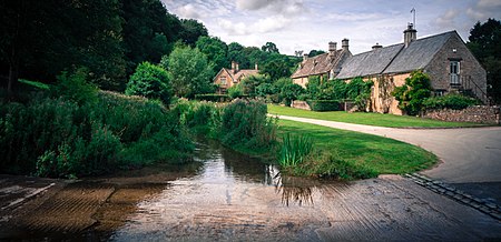
Upper Slaughter
AC with 0 elementsCotswold DistrictUse British English from March 2015Villages in Gloucestershire

Upper Slaughter is a village in the Cotswold district of Gloucestershire, England, 4 miles (6.4 km) south west of Stow-on-the-Wold. Nearby places include Lower Slaughter, Bourton-on-the-Water and Daylesford. The village is built on both banks of the River Eye. The Anglican parish church is dedicated to St. Peter.Upper Slaughter was one of the Thankful Villages, amongst the small number in England which lost no men in World War I. The village also lost no men in World War II, an honour known as a Doubly Thankful Village. The parliamentary constituency is represented by Geoffrey Clifton-Brown MP.
Excerpt from the Wikipedia article Upper Slaughter (License: CC BY-SA 3.0, Authors, Images).Upper Slaughter
Cotswold District Lower Slaughter
Geographical coordinates (GPS) Address Nearby Places Show on map
Geographical coordinates (GPS)
| Latitude | Longitude |
|---|---|
| N 51.906 ° | E -1.777 ° |
Address
GL54 2QA Cotswold District, Lower Slaughter
England, United Kingdom
Open on Google Maps


