Saint-Forget

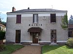
Saint-Forget (French pronunciation: [sɛ̃ fɔʁʒɛ]) is a commune in the Yvelines department in the Île-de-France region in north-central France. The commute consists of three hamlets: Le Mesnil-Sevin, Haute-Beauce, and The Sablons. This small town is 30 kilometers from Paris. It is nestled in the heart of the Regional Natural Park of the Upper Chevreuse Valley. As of 2019, there are 241 dwellings in the commune, of which 202 primary residences.The commune contains a small town hall that currently offers tours and/or visits. This small commune also includes many sites of interest for a small tour, including the Castle of Mauvières and the Saint Gilles Saint Ferréol church, which includes medieval frescoes. The castle, which used to be a manor, dates back to the 17th and 18th centuries.
Excerpt from the Wikipedia article Saint-Forget (License: CC BY-SA 3.0, Authors, Images).Saint-Forget
Chemin de la Butte, Rambouillet
Geographical coordinates (GPS) Address Nearby Places Show on map
Geographical coordinates (GPS)
| Latitude | Longitude |
|---|---|
| N 48.7083 ° | E 1.9969 ° |
Address
Chemin de la Butte
Chemin de la Butte
78720 Rambouillet
Ile-de-France, France
Open on Google Maps


